Black Tooth Mountain
From Wikipedia, the free encyclopedia
| Black Tooth Mountain | |
|---|---|
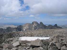
 Black Tooth Mountain, as viewed from the summit of Cloud Peak. | |
| Elevation | 13,005 ft (3,964 m) |
| Prominence | 645 ft (197 m)[1] |
| Location | |
| Location | Big Horn / Johnson counties, Wyoming, U.S. |
| Range | Bighorn Mountains |
| Coordinates | 44°24′12″N 107°10′46″W / 44.40333°N 107.17944°WCoordinates: 44°24′12″N 107°10′46″W / 44.40333°N 107.17944°W |
| Topo map | USGS Cloud Peak |
Black Tooth Mountain (13,005 ft / 3,964 m) is located in the Bighorn Mountains in the U.S. state of Wyoming.[2] The peak is the second highest in the range after Cloud Peak. The summit is located in the Cloud Peak Wilderness of Bighorn National Forest. The sharp profile of the mountain gives it the name Black Tooth. Because of the steep terrain, Black Tooth mountain is one of the hardest mountains to climb in the Big Horn Mountains. Many of the trails up the mountain are unmarked which adds to the difficulty of reaching the summit.
Cited references
- ↑ "Black Tooth Mountain, Wyoming". Peakbagger.com. Retrieved 2007-06-18.
- ↑ "USGS Cloud Peak (WY) Wyoming Topo" (Map). TopoQuest (USGS Quads). Retrieved 2008-06-29.
This article is issued from Wikipedia. The text is available under the Creative Commons Attribution/Share Alike; additional terms may apply for the media files.