Blönduós
From Wikipedia, the free encyclopedia
| Blönduós | |
|---|---|
| Town and Municipality | |
 | |
 | |
 Blönduós | |
| Coordinates: 65°40′N 20°18′W / 65.667°N 20.300°W | |
| Country | Iceland |
| Constituency[1] | Norðvesturkjördæmi |
| Region[2] | Norðurland vestra |
| County | Austur-Húnavatnssýsla |
| Municipality | Blönduós |
| Population (January 2011) | |
| • Town and Municipality | 904 |
| • Urban | 842 |
| Time zone | GMT (UTC+0) |
| Póstnúmer | 540 |
| Twin cities | |
| • Moss[citation needed] | Norway |
| • Karlstad[citation needed] | Sweden |
| Website | Official website |
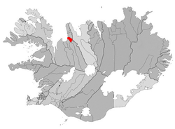
Blönduós is a town and municipality in the north of Iceland, in the county of Austur-Húnavatnssýsla, 245 km from Reykjavík.
The town has a population of around 850 and a small 9-hole golf course, and is a good base for touring the Húnaflói area.
Geography
Blönduós is situated on Route 1 at the mouth of the glacial river Blanda for which it is named (Blöndu is an oblique case of Blanda). On a hill above the town is a church with striking architecture that is intended to resemble a volcanic crater.
Overview
Blönduós does not have a good harbour, but the settlement's main role is as a dairy service center for the surrounding farm areas.
Photogallery
-

Houses in Blönduós
-

Houses in Blönduós
-

A boat in drydock
-

Mouth of Blanda river
References
External links
| |||||||||||
Coordinates: 65°40′N 20°18′W / 65.667°N 20.300°W
This article is issued from Wikipedia. The text is available under the Creative Commons Attribution/Share Alike; additional terms may apply for the media files.
