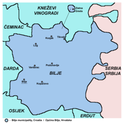
Bilje
| Bilje | |
|---|---|
| Municipality | |
| Bilje Municipality Općina Bilje | |
 Bilje | |
| Coordinates: 45°36′25″N 18°44′38″E / 45.60694°N 18.74389°ECoordinates: 45°36′25″N 18°44′38″E / 45.60694°N 18.74389°E | |
| Government | |
| • Mayor | Žarko Zelić |
| Area | |
| • Total | 344 km2 (133 sq mi) |
| Elevation | 87 m (285 ft) |
| Population | |
| • Total | 5,642 |
| Time zone | Central European Time (UTC+1) |

Bilje is a village and municipality on the outskirts of nature park Kopački Rit in the region of Baranja, Osijek-Baranja County, Croatia, situated 8 km northeast of Osijek.
Name
Its name derived from the Slavic word "bilje" ("herb" in English). In German the village is known as Belje, in Hungarian as Bellye,[1] and in Serbian Cyrillic as Биље.
Geography
The municipality of Bilje include following settlements and population (2011 census):[2]
- Bilje - 3,613
- Kopačevo - 559
- Kozjak - 60
- Lug - 764
- Podunavlje - 1
- Tikveš - 10
- Vardarac - 630
- Zlatna Greda - 5
Demographics
There are 5,642 inhabitants in the municipality (2011 census),[2] including:[3]
- 62.87% Croats
- 29.62% Hungarians
- 3.83% Serbs
- 1.05% Germans
- 0.71% Romani
Features
Chief occupations among the population are farming, livestock breeding and food processing (a mill). The manor with the park represents the major tourist attraction; the park is protected as a horticultural monument.
The neighbouring village of Mece is the centre of one of the oldest industrial-agricultural cooperative farms in Europe Belje.
Kopački Rit, situated at the confluence of the Drava and the Danube, the unique preserved wetland area in this part of Europe is not far from Mece. The area surrounding Kopački Rit offers rich hunting grounds for high game (deer in particular) and equally opulent fishing grounds.
See also
- Osijek-Baranja County
- Baranja
References
- ↑ "Registar Geografskih Imena Nacionalnih Manjina Republike Hrvatske" (PDF). Retrieved 2013-03-08.
- ↑ 2.0 2.1 "Population by Age and Sex, by Settlements, 2011 Census: Bilje". Zagreb: Croatian Bureau of Statistics. December 2012.
- ↑ "Population by Ethnicity, by Towns/Municipalities, 2011 Census: County of Osijek-Baranja". Zagreb: Croatian Bureau of Statistics. December 2012.
