Bijuli
From Wikipedia, the free encyclopedia
| Bijuli बिजुली | |
|---|---|
| Village Development Committee | |
 Bijuli | |
| Coordinates: 28°02′N 82°57′E / 28.03°N 82.95°ECoordinates: 28°02′N 82°57′E / 28.03°N 82.95°E | |
| Country |
|
| Region | Mid-Western |
| Zone | Rapti Zone |
| District | Pyuthan District |
| VDC | Bijuli |
| Population (2001 Census[1]) | |
| • Total | 3,666 |
| 697 households | |
| Time zone | Nepal Time (UTC+5:45) |
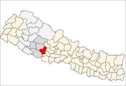
Bijuli is a town and Village Development Committee in Pyuthan, a Middle Hills district of Rapti Zone, western Nepal.
Etymology
Bijuli means lightning or electricity.
Villages in VDC
| Ward | Lat. | Lon | Elev. | ||
|---|---|---|---|---|---|
| Aitar | ऐटार | 28°00'N | 82°57'E | 630m | |
| Arlabang | अर्लबाङ | 28°01'N | 82°57'E | 630 | |
| Baghkhor | बाघखोर | 28°02'N | 82°57'E | 1,150 | |
| Bahunthok | बाहुनथोक | 28°02'N | 82°57'E | 1,255 | |
| Baireni | बैरेनी | 6 | 28°00'N | 82°57'E | 670 |
| Baram Pokhara | बरम पोखरा | 28°01'N | 82°58'E | 1,135 | |
| Barthan | बरथान | 28°01'N | 82°57'E | 1,352 | |
| Basdanda | बासडाँडा | 1 | 28°03'N | 82°56'E | 1,110 |
| Batule | बाटुले | 28°02'N | 82°58'E | 835 | |
| Bijuli | बिजुली | 28°02'N | 82°57'E | 1,212 | |
| Chidiyapakha | चिडियापाखा | 28°01'N | 82°58'E | 973 | |
| Chiurapani | चिउरापानी | 3 | 28°02'N | 82°57'E | 1,210 |
| Damar | दमार | 28°00'N | 82°57'E | 765 | |
| Dhairechaur | धैरेचौर | 28°02'N | 82°58'E | 1,010 | |
| Dhanphule | धनफूले | 28°02'N | 82°56'E | 1,130 | |
| Gahatera | गहतेरा | 28°00'N | 82°58'E | 670 | |
| Hattipaila | हात्तिपाइला | 9 | 28°02'N | 82°58'E | 1,038 |
| Kanle | कान्ले | 28°03'N | 82°57'E | 920 | |
| Ladam | लादम | 28°01'N | 82°57'E | 650 | |
| Madahi | मडाही | 28°01'N | 82°57'E | 1,135 | |
| Mahindra Dip | महिन्द्रा दिप | 28°02'N | 82°58'E | 794 | |
| Okhaldhunga | ओखलढुङ्गा | 28°02'N | 82°58'E | 1,109 | |
| Rahakholagaun | रहखोलागाउँ | 28°01'N | 82°58'E | 685 | |
| Simethum | सिमेथुम | 28°01'N | 82°58'E | 1,279 | |
| Sineta | सिनेटा | 28°00'N | 82°58'E | 901 | |
| Syani Tham | स्यानी थाम | 28°02'N | 82°56'E | 798 | |
| Tham | थाम | 28°02'N | 82°57'E | 1,182 | |
| Udik | उदिक | 5 | 28°01'N | 82°56'E | 645 |
References
- ↑ "Nepal Census 2001". Nepal's Village Development Committees. Digital Himalaya. Archived from the original on 12 October 2008. Retrieved 21 September 2008.
- ↑ "Index of Geographical Names of Nepal, Volume IV: Mid Western Development Region, List of Settlements, Pyuthan". Government of Nepal, National Geographic Information Infrastructure Program. Retrieved 2011-03-12.
External links
| |||||||||||
This article is issued from Wikipedia. The text is available under the Creative Commons Attribution/Share Alike; additional terms may apply for the media files.
