Bigsweir
Bigsweir is a locality in the Wye Valley Area of Outstanding Natural Beauty, which straddles the boundary between Gloucestershire in England and Monmouthshire in Wales. It is located about 2 miles north of Llandogo, 2 miles south of Whitebrook, and 3 miles west of St. Briavels. It is the Normal Tidal Limit (NTL) of the River Wye, and navigation below this point falls under the jurisdiction of the Gloucester Harbour Trustees.
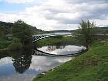
There is no village at Bigsweir. However, it is known for its elegant cast iron road bridge, which was built in 1827 as part of the new turnpike road constructed up the lower part of the Wye valley between Chepstow and Monmouth. The bridge connects the English and Welsh sides of the river, with an abandoned but recently restored toll house on the Welsh side.[1] The bridge comprises a single arch of 50 metres, and was designed by Charles Hollis of London and cast at Merthyr Tydfil.[2] Because of its narrow width, modern traffic using the A466 is controlled by traffic signals at either end. The bridge is about 600 metres upstream of the ancient fishing weir and ford of Bigsweir, which is close to Bigsweir House.[3]
Bigsweir was also the site of St. Briavels railway station, on the now disused Wye Valley Railway.
See also
References
| Wikimedia Commons has media related to Bigsweir. |
- ↑ Monmouthshire Beacon, Historic toll house at Bigsweir under restoration, 22 February 2012. Accessed 12 October 2012
- ↑ Alan Crow, Bridges on the River Wye, 1995, ISBN 0-9518589-9-8
- ↑ British History Online - St Briavels
Coordinates: 51°44′40″N 2°40′5″W / 51.74444°N 2.66806°W