Bietigheim (Baden)
From Wikipedia, the free encyclopedia
| Bietigheim | ||
|---|---|---|
 | ||
| ||
 Bietigheim | ||
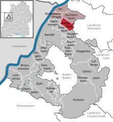
Location of Bietigheim within Rastatt district 
 | ||
| Coordinates: 48°54′37″N 08°15′11″E / 48.91028°N 8.25306°ECoordinates: 48°54′37″N 08°15′11″E / 48.91028°N 8.25306°E | ||
| Country | Germany | |
| State | Baden-Württemberg | |
| Admin. region | Karlsruhe | |
| District | Rastatt | |
| Government | ||
| • Mayor | Ernst Kopp (SPD) | |
| Area | ||
| • Total | 13.90 km2 (5.37 sq mi) | |
| Elevation | 121 m (397 ft) | |
| Population (2012-12-31)[1] | ||
| • Total | 6,150 | |
| • Density | 440/km2 (1,100/sq mi) | |
| Time zone | CET/CEST (UTC+1/+2) | |
| Postal codes | 76462–76467 | |
| Dialling codes | 07245 | |
| Vehicle registration | RA | |
| Website | www.bietigheim.de | |
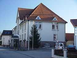
Bietigheim is a village in the district of Rastatt in Baden-Württemberg in Southwestern Germany.
Population
Bietigheim has 6017 inhabitants.
Neighbour towns and villages
Bietigheim borders on the following towns, clockwise beginning from the north: Durmersheim, Malsch, Muggensturm, Ötigheim, Steinmauern, Elchesheim-Illingen.
Geography
The village is located between the river Rhine and the black forest. There is also a valley in the forest, named Hardtwald. The 27 kilometres long Federbach River flows from south to north through the village.
The nearest big city is Karlsruhe, c. 17 km north of the village. The nearest airport is the Airport Karlsruhe/Baden-Baden.
| |||||||
References
- ↑ [Statistisches Bundesamt – Gemeinden in Deutschland mit Bevölkerung am 31.12.2012 (XLS-Datei; 4,0 MB) (Einwohnerzahlen auf Grundlage des Zensus 2011) "Gemeinden in Deutschland mit Bevölkerung am 31.12.2012"]. Statistisches Bundesamt (in German). 12 November 2013.
This article is issued from Wikipedia. The text is available under the Creative Commons Attribution/Share Alike; additional terms may apply for the media files.
