Bienenbüttel
| Bienenbüttel | ||
|---|---|---|
| ||
 Bienenbüttel | ||
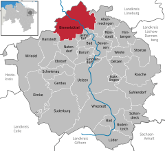
Location of Bienenbüttel within Uelzen district 
 | ||
| Coordinates: 53°8′36″N 10°29′25″E / 53.14333°N 10.49028°ECoordinates: 53°8′36″N 10°29′25″E / 53.14333°N 10.49028°E | ||
| Country | Germany | |
| State | Lower Saxony | |
| District | Uelzen | |
| Subdivisions | 14 districts | |
| Government | ||
| • Mayor | Heinz-Günter Waltje (CDU) | |
| Area | ||
| • Total | 99 km2 (38 sq mi) | |
| Elevation | 30 m (100 ft) | |
| Population (2012-12-31)[1] | ||
| • Total | 6,632 | |
| • Density | 67/km2 (170/sq mi) | |
| Time zone | CET/CEST (UTC+1/+2) | |
| Postal codes | 29553 | |
| Dialling codes | 05823 | |
| Vehicle registration | UE | |
| Website | www.bienenbuettel.de | |
Bienenbüttel is a free municipality in the district of Uelzen, in Lower Saxony, Germany. It is situated on the river Ilmenau, approx. 20 km north of Uelzen, and 13 km southeast of Lüneburg. Bienenbüttel is a part of the Hamburg Metropolitan Region and of the Lüneburg Heath (Lüneburger Heide).
Bienenbüttel is the seat of the Einheitsgemeinde ("free municipality") Bienenbüttel. Incorporated into the municipality are the villages of Bargdorf, Beverbeck with Grünewald, Bornsen, Edendorf, Eitzen I with Bardenhagen, Grünhagen, Hohenbostel, Hohnstorf, Niendorf, Rieste with Neu-Rieste, Steddorf with Neu-Steddorf, Varendorf, Wichmannsburg and Wulfstorf.
Bienenbüttel is located at the Elbe-Seitenkanal a 115 km long waterway. Bienenbüttel also is a station of the highspeed rail route Hamburg-Uelzen-Hannover
| |||||||
