Bhimber
| Bhimber بھمبر | |
|---|---|
| Door to Kashmir | |
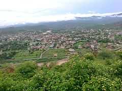 | |
 Bhimber | |
| Coordinates: 32°35′N 74°02′E / 32.58°N 74.04°ECoordinates: 32°35′N 74°02′E / 32.58°N 74.04°E | |
| Country | Pakistan |
| Territory | Azad Kashmir |
| District | Bhimber District |
| Established | 7th century AD |
| Government | |
| • Nazim (Chairman City) | Chaudhry Waleed Ashraf |
| Time zone | PST (UTC+5) |
| Postal code | 10040 |
| Dialling code | 0092-05828 |
| Website | Official Website |
Bhimber (Urdu: بھمبر) is the chief town of Bhimber District, Azad Kashmir. The town is situated on the border between Azad Kashmir and Pakistan at a distance of about 50 km (31 mi) from Mirpur, about 48 kilometres (30 mi) from Gujrat, about 37 kilometres (23 mi) from Jhelum, about 166 kilometres (103 mi) from Islamabad and about 241 kilometres (150 mi) from Srinagar.[1]
History
Famous Chinese tourist Hune Sang has talked about Bhimber in his journeys in seventh century A.D. For centuries, Bhimber has remained as capital city of Chibhal. Raja Chib Chand who was the first Chib came to Bhimber about 1400 years ago. In Chibs, the first who embraced Islam was Sirsadi who is famous as Hazrat Baba Shadi Shaheed. He died during the reign of King Aurangzeb Alamgir. The last ruler of Chibhals was Raja Sultan Khan (1800–1840). Bhimber has been important strategically. It lies on the route that was followed by the Mughal Emperors for their frequent visits to the Kashmir Valley. It is also known as "Baab-e-Kashmir" (Door to Kashmir) because of its importance and geographical location which was ideal for Mughal Emperors to enter Kashmir. Therefore, the Mughals used Bhimber as a staging point for journey to Srinagar. Mughal Emperor Jahangir discussed Bhimber in his book Tuzk-e-Jahangiri.[2]
Culture
Native people and people migrated from Samahni Valley speak Pahari. Bhimber is situated at the border of Azad Kashmir and Punjab, so Pahari dialect influenced by Punjabi is also used.
Geography and climate
The Bhimber region is only region in Azad Kashmir which consists of plains. Its hot, dry climate and other geographical conditions closely resemble with those of Gujrat, the adjoining district of Pakistan.
Ethnic groups in Bhimber
- Arain – A minority group, mostly engaged in commercial businesses.
- Jatts – Represent biggest of the three majority ethnic groups of Bhimber. They play an active role in politics and bureaucracy. They are a tribe with a very strong history and are noble barons and landlords (Jagirdars).
- Kashmiri – Minority clans in Bhimber are Butt, Lone, Dar and Khawaja. They are the descendants of Kashmiri pundits, who belonged to the priestly caste of Brahmins and migrated from Kashmir Valley.
- Mughals – The third of three major ethnic groups. Although they are not involved in active political activities, they are highly active in the education sector.
- Rajputs – Second of the three major ethnic groups in number, they play an active role in politics and bureaucracy. They comprise many clans, mainly Chibs.
- Sheikh – Most people who classify themselves as Sheikhs in Bhimber are descendants of Brahmin, Khatri or Rajput Hindus who converted to Islam.
- Sayyids – Though a minority group they are a very active people and occupy important positions in all sectors.
Tourism
Bhimber and its surrounding area is very rich in archaeological remains. There is a forest rest house in Bhimber. Famous historical and scenic sites in the town and surrounding area include:
- Baghsar Fort – This ancient fort is built in Samahni Valley close to a place known as Baghsar.
- Baghsar Lake – This lake is situated near Baghsar Fort.
- Famous Haathi Gate – Jahangir's elephant used to enter the town through it.
- Jandi Chontra – This is the place from where Srinagar and Lahore are at the same distance.
- Sarai Saadabad – The Sarai is located near Bandala in the Samahni Valley. It was used as a staging camp during Mughal Era for the caravans moving from Lahore to Kashmir.
- Tomb of sufi saint Baba Shadi Shaheed.
Transportation
Buses
Common public transport is Hiace. Daily routes include Mirpur, Gujrat, Dina, Jhelum, Gujranwala and Kharian. The coaches and coasters travel to larger cities of Pakistan including Lahore, Faisalabad, Rawalpindi and Gujranwala.
Air
The nearest commercial airport was the Islamabad International Airport, which is approximately 166 km by road from Bhimber. Recently, Sialkot International Airport has become operational which is about 150 km from town. So, this is most suitable for the people. There is a small military air strip in the town.
Educational institutes
·===Schools and colleges===
- Allied School System
- Army Public School & College
- Bhimber Public School
- Crescent Model College
- Dar-e-Arqam School System
- F.G. Ashiq Husain Public School
- Government City High School
- Government Degree College for Girls
- Government Girls High School
- Government Pilot High School for Boys
- Government Post Graduate College for Boys
- Insight Model school College
- Institute of Education
- Khan Muhammad Khan College Of Education & Technology
- Little Angels Public School
- Minhaj-ul-Quran Public School
- READ Foundation Degree College
- The Learners
- Muslims Hands Model School
- Science Foundation High School
Muslims Hands Model School
See also
- Baba Shadi Shaheed
- District Bhimber
- Jammu Kashmir Liberation Front
- Maqbool Bhat
- Mirpur
- Pahari
- Barnala Azad Kashmir
References
- ↑ Government of Azad Jammu & Kashmir Website. "Distance from other cities.". Retrieved 8 December 2011.
- ↑ Government of Azad Jammu & Kashmir Website. "Jahangir discussed Bhimber in his book Tuzk-e-Jahangiri.". Retrieved 8 December 2011.