Beuningen
From Wikipedia, the free encyclopedia
For the village in Overijssel, see Beuningen, Overijssel.
| Beuningen | |||
|---|---|---|---|
| Municipality | |||
_town_hall.JPG) | |||
| |||
 | |||
| Coordinates: 51°52′N 5°46′E / 51.867°N 5.767°ECoordinates: 51°52′N 5°46′E / 51.867°N 5.767°E | |||
| Country | Netherlands | ||
| Province | Gelderland | ||
| Area(2006) | |||
| • Total | 47.17 km2 (18.21 sq mi) | ||
| • Land | 43.86 km2 (16.93 sq mi) | ||
| • Water | 3.30 km2 (1.27 sq mi) | ||
| Population (1 January, 2007) | |||
| • Total | 25,260 | ||
| • Density | 576/km2 (1,490/sq mi) | ||
| Source: CBS, Statline. | |||
| Time zone | CET (UTC+1) | ||
| • Summer (DST) | CEST (UTC+2) | ||
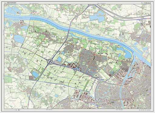
Beuningen (![]() pronunciation (help·info)) is a municipality and a town in the eastern Netherlands close to the city of Nijmegen. The municipality consists of the towns Beuningen, Ewijk, Winssen and Weurt. 1 Mile to the north lies the river Waal
pronunciation (help·info)) is a municipality and a town in the eastern Netherlands close to the city of Nijmegen. The municipality consists of the towns Beuningen, Ewijk, Winssen and Weurt. 1 Mile to the north lies the river Waal
Beuningen lies in the armpit of the A73 (Nijmegen-Venlo, on the south side) and A50 (Zwolle-Eindhoven, in the west) motorway interchange. In the north it borders the river Waal and Nijmegen in the east. Beuningen has a population of 25,074 (May 1 2006).
Population centres
Topography

Dutch Topographic map of the municipality of Beuningen, 2013.

Beuningen, church: de Corneliuskerk
External links
 Media related to Beuningen, Gelderland at Wikimedia Commons
- Official Website
 |
Neder-Betuwe Waal |
Overbetuwe Waal |
 | |
| Druten | |
Nijmegen | ||
| ||||
| | ||||
| Wijchen |
This article is issued from Wikipedia. The text is available under the Creative Commons Attribution/Share Alike; additional terms may apply for the media files.


