Betzenweiler
From Wikipedia, the free encyclopedia
| Betzenweiler | ||
|---|---|---|
| ||
 Betzenweiler | ||
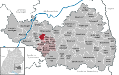
Location of Betzenweiler within Biberach district 
 | ||
| Coordinates: 48°7′2″N 9°34′28″E / 48.11722°N 9.57444°ECoordinates: 48°7′2″N 9°34′28″E / 48.11722°N 9.57444°E | ||
| Country | Germany | |
| State | Baden-Württemberg | |
| Admin. region | Tübingen | |
| District | Biberach | |
| Government | ||
| • Mayor | Dietmar Rehm | |
| Area | ||
| • Total | 9.70 km2 (3.75 sq mi) | |
| Elevation | 579 m (1,900 ft) | |
| Population (2012-12-31)[1] | ||
| • Total | 732 | |
| • Density | 75/km2 (200/sq mi) | |
| Time zone | CET/CEST (UTC+1/+2) | |
| Postal codes | 88422 | |
| Dialling codes | 07374 | |
| Vehicle registration | BC | |
| Website | www.betzenweiler.de | |
Betzenweiler is a municipality in the Biberach district of Baden-Württemberg, in southwestern Germany.
The 9.70 square kilometre area is between the Federseebasin and the Bussen, the largest mountain in central Swabia. The official language is German, day-to-day conversations by almost all of its inhabitants are in Swabian dialect.
Relative to its size of ca. 713 Betzenweiler has got a big industry and more in-commuters than out-commuters.
There are about 15 bigger companies, some with more than 200 employees, and a lot of small ones.
References
- ↑ [Statistisches Bundesamt – Gemeinden in Deutschland mit Bevölkerung am 31.12.2012 (XLS-Datei; 4,0 MB) (Einwohnerzahlen auf Grundlage des Zensus 2011) "Gemeinden in Deutschland mit Bevölkerung am 31.12.2012"]. Statistisches Bundesamt (in German). 12 November 2013.
This article is issued from Wikipedia. The text is available under the Creative Commons Attribution/Share Alike; additional terms may apply for the media files.
