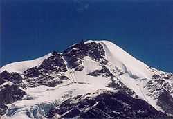
Berinag
From Wikipedia, the free encyclopedia

a Himalayan peak
| Berinag | |
|---|---|
| town hill | |
 Berinag | |
| Coordinates: 29°48′N 80°04′E / 29.80°N 80.07°ECoordinates: 29°48′N 80°04′E / 29.80°N 80.07°E | |
| Country |
|
| State | Uttarakhand |
| District | Pithoragarh |
| Elevation | 1,860 m (6,100 ft) |
| Languages | |
| • Official | Hindi |
| Time zone | IST (UTC+5:30) |
Berinag, a tiny hill station, is located 12 km from Chaukori in the Pithoragarh district, the most eastern Himalayan district in the state of Uttarakhand, India. It is accessible by road. Closest prominent villages include Garawon,Dhanoli, Bana, Bhattigaon, Banoli,quarali,tripuradevi and Sangarh. A quite, beautiful and worthseeing place known for sight seeing of Himalaya peaks Such as Nandadevi and Panchachuli.
Geography
Berinag is located at 29°48′N 80°04′E / 29.80°N 80.07°E.[1] It has an average elevation of 1,740 metres (4,180 feet).
Transport
- Nearest airport is Naini Saini, Pithoragarh : 112 km.
- Nearest rail station is Kathgodam : 214 km.
- Chaukori is well connected by road with Almora-100 k, Nainital-183 km, Bageshwar-56 km, Pithoragarh-85 km[2]
Notes
- ↑ Falling Rain Genomics, Inc - Berinag
- ↑ "Chaukori". Retrieved 2006-09-24.
External links
- Pithoragar district website
- Map and photos of area
- Temples in the general area
- {http://berinag.com/ Tourist website ]
| ||||||||
This article is issued from Wikipedia. The text is available under the Creative Commons Attribution/Share Alike; additional terms may apply for the media files.