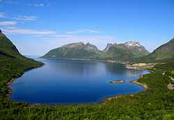
Berg, Norway
| Berg kommune Birgi suohkan | |||
|---|---|---|---|
| Municipality | |||
 | |||
| |||
 | |||
| Coordinates: 69°28′0″N 17°23′52″E / 69.46667°N 17.39778°ECoordinates: 69°28′0″N 17°23′52″E / 69.46667°N 17.39778°E | |||
| Country | Norway | ||
| County | Troms | ||
| District | Midt-Troms | ||
| Administrative centre | Skaland | ||
| Government | |||
| • Mayor (2011) | Guttorm Nergård (Local list) | ||
| Area | |||
| • Total | 294.09 km2 (113.55 sq mi) | ||
| • Land | 276.54 km2 (106.77 sq mi) | ||
| • Water | 17.55 km2 (6.78 sq mi) | ||
| Area rank | 280 in Norway | ||
| Population (2012) | |||
| • Total | 887 | ||
| • Rank | 407-408 in Norway | ||
| • Density | 3.2/km2 (8/sq mi) | ||
| • Change (10 years) | -16.4 % | ||
| Demonym | Bergsværing[1] | ||
| Time zone | CET (UTC+1) | ||
| • Summer (DST) | CEST (UTC+2) | ||
| ISO 3166 code | NO-1929 | ||
| Official language form | Bokmål | ||
| Website | www.berg.kommune.no | ||
|
| |||
Berg is a municipality in Troms county, Norway. The administrative centre of the municipality is the village of Skaland. Other villages include Finnsæter, Mefjordvær, and Senjahopen.
The municipality was the first place in the world to utilize a hydroelectrical power station in the mining community of Hamn. When the mining industry ceased, the "electrical adventure" did as well. The buildings are still located at Hamn, now functioning as a special hotel/lodge.
The first female pastor in the Lutheran Church of Norway, Ingrid Bjerkås, worked in this parish, starting in 1961.
General information


Berg was established as a municipality on 1 January 1838 (see formannskapsdistrikt). The southern part of Berg (population: 1,229) was separated from Berg to form the new municipality of Torsken on 1 January 1902. This left Berg with 1,002 residents. The municipal borders have not changed since.[2]
Name
The municipality (originally the parish) is named after the old Berg farm (Old Norse: Berg). The name is identical with the word berg which means "mountain".
Coat-of-arms
The coat-of-arms is from modern times. They were granted on 2 October 1987. The profile represents the three mountains of Trælen, Oksen, and Kjølva. The colors represent "winter darkness", "black sea", and "toward brighter times."[3]
Churches
The Church of Norway has one parish (sokn) within the municipality of Berg. It is part of the Senja deanery in the Diocese of Nord-Hålogaland.
| Parish (Sokn) | Church Name | Location of the Church | Year Built |
|---|---|---|---|
| Berg | Berg Church | Skaland | 1955 |
| Finnsæter Chapel | Finnsæter | 1982 | |
| Mefjordvær Chapel | Mefjordvær | 1916 |
Geography
The municipality faces the Atlantic Ocean on the west side of the large island of Senja. The largest urban area in Berg is the village of Senjahopen. The highest point on the island, the mountain Breidtinden, is located in the northeastern part of Berg. There are three large fjords that cut into the municipality: Bergsfjorden, Ersfjorden, and Mefjorden.
Climate
| Climate data for Skaland, Berg | |||||||||||||
|---|---|---|---|---|---|---|---|---|---|---|---|---|---|
| Month | Jan | Feb | Mar | Apr | May | Jun | Jul | Aug | Sep | Oct | Nov | Dec | Year |
| Daily mean °C (°F) | −2.5 (27.5) |
−2.5 (27.5) |
−1.4 (29.5) |
1.2 (34.2) |
5.3 (41.5) |
8.8 (47.8) |
11.3 (52.3) |
11.1 (52) |
7.8 (46) |
4.1 (39.4) |
0.6 (33.1) |
−1.6 (29.1) |
3.5 (38.3) |
| Precipitation mm (inches) | 109 (4.29) |
94 (3.7) |
88 (3.46) |
77 (3.03) |
55 (2.17) |
67 (2.64) |
77 (3.03) |
91 (3.58) |
115 (4.53) |
152 (5.98) |
129 (5.08) |
131 (5.16) |
1,185 (46.65) |
| Source: Norwegian Meteorological Institute[4] | |||||||||||||
References
- ↑ "Personnemningar til stadnamn i Noreg" (in Norwegian). Språkrådet.
- ↑ Jukvam, Dag (1999). "Historisk oversikt over endringer i kommune- og fylkesinndelingen" (in Norwegian). Statistisk sentralbyrå.
- ↑ "Beskrivelse av kommunevåpenet" (in Norwegian). Retrieved 2008-12-01.
- ↑ "eKlima Web Portal". Norwegian Meteorological Institute.
External links
-
 Media related to Berg (Senja) at Wikimedia Commons
 -
 The dictionary definition of Berg at Wiktionary
 -
 Senja travel guide from Wikivoyage
 - Municipal fact sheet from Statistics Norway
| ||||||||||

