Bendora Dam
| Bendora Dam | |
|---|---|
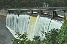 Bendora Dam in spill, 2010 | |
| Country | Australia |
| Location | Australian Capital Territory |
| Coordinates | 35°26′49″S 148°49′41″E / 35.447°S 148.828°ECoordinates: 35°26′49″S 148°49′41″E / 35.447°S 148.828°E |
| Purpose | Potable water supply |
| Status | Operational |
| Opening date | 1961 |
| Owner(s) | ACTEW Corporation |
| Dam and spillways | |
| Type of dam | Double curvature concrete arch |
| Impounds | Cotter River |
| Height | 47.2 metres (155 ft) |
| Elevation at crest | 778.2 metres (2,553 ft) |
| Dam volume | 11,540 megalitres (408×106 cu ft) |
| Reservoir | |
| Creates | Bendora Reservoir |
| Surface area | 71 hectares (180 acres) |
|
Website Bendora Dam at ACTEW Corporation | |
Bendora Dam, a thin-wall, double curvature concrete arch dam on the upper reaches of the Cotter River, is located within Namadgi National Park in the Australian Capital Territory, Australia.
The dam was opened in 1961 and was the first dam of its type built in Australia.[1] Bendora Dam, together with Corin Dam (further upstream), are two of the supply sources of potable water for the city of Canberra and its environs; that is pumped via the Bendora Gravity Main.
The dam wall is 47.2 metres (155 ft) high and holds back 11,540 megalitres (408×106 cu ft) of water held within Bendora Reservoir, forming a surface area of approximately 71 hectares (180 acres).[2][3]
See also
![]() Australian Capital Territory portal
Australian Capital Territory portal
- Dams in Australia
References
- ↑ Andrews, W.C, ed. (1990). Canberra's Engineering Heritage (2nd ed.). Canberra: Institution of Engineers. ISBN 0-85825-189-2.
- ↑ "Map of Bendora Dam, ACT". Bonzle Digital Atlas of Australia. Retrieved 17 February 2013.
- ↑ "Bendora Dam". Water storage. ACTEW Corporation. 2011. Retrieved 17 February 2013.
External links
![]() Media related to Bendora Dam at Wikimedia Commons
Media related to Bendora Dam at Wikimedia Commons
| ||||||||||||||