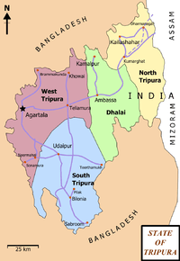
Belonia, India
| Belonia Suman chakraborty | |
|---|---|
| city | |
| Nickname(s): suman | |
 Belonia | |
| Coordinates: 23°15′N 91°27′E / 23.25°N 91.45°ECoordinates: 23°15′N 91°27′E / 23.25°N 91.45°E | |
| Country | India |
| State | Tripura |
| District | South Tripura |
| Government | |
| • Type | u.b.i bank |
| Area rank | 2 |
| Elevation | 23 m (75 ft) |
| Population (2001) | |
| • Total | 15,687 |
| Languages | |
| • Official | Bengali, Kokborok, English |
| Time zone | IST (UTC+5:30) |
| Telephone code | 03823 |
Belonia is a town and a nagar panchayat in South Tripura district in the state of Tripura, India. It is also the head-quarter of South Tripura district. It is linked with Agartala, the state capital, with highway via radhanagar.Belonia has a border with Bangladesh . foreigner tourists can also use that route to bangaldesh .
Geography

Belonia is located at 23°15′N 91°27′E / 23.25°N 91.45°E.[1] It has an average elevation of 23 metres (75 feet).
Demographics
As of 2001 India census,[2] Belonia had a population of 15,687. Males constitute 52% of the population and females 48%. Belonia has an average literacy rate of 95%, higher than the national average of 59.5%; with 54% of the males and 46% of females literate. 9% of the population is under 6 years of age.
Education
Schools:- A) Brajendra Kishore Institution B) Vidyapith HS School C) Aryya Colony HS School D) radhanagar hs school
College:- A) Belonia Collage B) ITI Collage
Politics
Belonia assembly constituency is part of Tripura SOUTH - VIDHAN SABHA & West (Lok Sabha constituency).[3]
References
- ↑ Falling Rain Genomics, Inc - Belonia
- ↑ "Census of India 2001: Data from the 2001 Census, including cities, villages and towns (Provisional)". Census Commission of India. Archived from the original on 2004-06-16. Retrieved 2008-11-01.
- ↑ "Assembly Constituencies - Corresponding Districts and Parliamentary Constituencies". Tripura. Election Commission of India. Retrieved 2008-10-08.
See also