Belgharia
| Belghari বেলঘড়িয়া | |
|---|---|
| Neighbourhood in Kolkata (Calcutta) | |
 Belghari | |
| Coordinates: 22°39′N 88°23′E / 22.65°N 88.38°ECoordinates: 22°39′N 88°23′E / 22.65°N 88.38°E | |
| Country |
|
| State | West Bengal |
| City | Kolkata |
| Languages | |
| • Official | Bengali, English, Hindi |
| Time zone | IST (UTC+5:30) |
| PIN | 700056, 700083 |
| Telephone code | 91 33 |

Ramakrishna Paramhansa visited this place 8 times and the 1st time was in 1875. Ramakrishna Mission also situated here and they run a Students' Home for meritorious poor and needy students along with a 3 year Diploma Engg. College . They are also conducting relief activities with a public library and homeopathic dispensary. Swami Vijnanananda, a direct disciple of Ramakrishna also resided here.Nearest Industrial area is Kamarhatty (3 km),Companies are Agarpara Jute Mill, Allied Ceramic,ESDEE Allumina,Emami,Kamarhatty Jute Mill,Texmaco,TIL,WIMCO.A small unit of Ramkrishna Mission situated here(near belgharia flyover) which is established by Swami Vijnananandaji, Architect of Belur Math.
Educational institutions
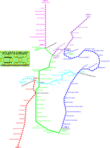
Kolkata new proposed metro rout (Baranagar - Barrackpore)
- Bhairab Ganguly College,
- Belgharia High School,
- Jatindas Vidyamandir,
- Udaypur Haradayal Nag Adarsha Vidyalaya
- Belgharia Mahakali Girls High School
- Belgharia Ramakrishna Mission (Polytechnic Institution)
- Trivasa Academy High School
- Desopriyo Vidyaniketan
- Nimta Higher Secondary School
- Udaypur Haradayal Nag Adarsha Vidyalaya
- Belgharia Jatiya Vidyaniketan
- Nandan Nagar High School
- Sishu Nalanda Primary School
- Alok Tirtha Nursary & KG School.
- Kajal Memorial School
- Adamas International school
- Adarsha Sishu Niketan, Nandan Nagar
- Sishu Niketan
- Rabindra Path Bhawan
Major Markets
- Belgharia Rail Bazar- For Fresh Vegetables & Fish
- Belgharia Municipal Market
- Dr. P.N.Dey market
- Sadananda Chawk
- Ghola Road bazar
Library
- Parry Mohun Library
- Belgharia Text Book Library
Hospitals and health centre
- Ariadah Matri Sadan.
- Sagar dutta Hospital.
- Midland nursing Home.
- Zenith Multispeciality Hospital.
- Sahid Khudiram bose hospital.
- Diagaid
Banks & ATM'S
- State Bank of India with ATM - Shankar Bhawan - Opposite Belgharia A C Market
- Bank of Baroda with ATM - Branch beside Belgharia Head Post Office, ATM at Belgharia Power House
- Allahabad Bank - Above Axis Bank - Opposite Belgharia Bata
- UCO Bank
- HDFC Bank with ATM - Opposite Bhairav Ganguly College
- AXIS Bank with ATM - Opposite Belgharia Bata
- Central Bank of India with ATM - Branch at P N Dey Market - ATM beside Belgharia Head Post Office
- ICICI Bank ATM - at Belgharia Badamtalla
- United Bank of India with ATM - at Belgharia Badamtalla
Communication Links to Kolkata and other places
Nearest two(2) Railway Station - Belgharia & Baranagar
- To Sealdah (North) via Local Train.
- To Sodepur via Local train, BT Road & Nilgunj road
- To Barrackpore via local train, BT Road.
- To BT Road via Feeder Road
- To Birati Railway Station Via MB Road
- To Baranagore Road Railway Station Via BT Road
- To Dakshineswar via Belgharia Expressway/Auto Route.
- To Dumdum Airport Via Belgharia Expressway*
- To Salt lake & New Town Via Belgharia Expressway*
The newly built Belghoria Expressway which links Jessore Road with Dumdum Airport and Nivedita Setu on Ganges increased the importance of this places.

The place is now beaming up with flats. People can have an easy access to anything within no time.
Belgharia still oozes old world charm of Bengal. The cosmopolitan culture of new age Bengal hasn't yet penetrated the town. The population consists of generally middle class Bengali. Of late a lot of student messes has sprung up chiefly because of the low cost of living and close proximity to the city of Kolkata.
Belgharia is an area under Kamarhati Municipality and some parts fall under the area of North Dumdum Municipality.
NOTE: It has a very old history which is unknown to the most.Here is a canal called Bagjola canal.Some details have been in some 14th century's text written by Mughals. It had a big market beside Nadikul (Nimta). Very Dangerous areas were modern day Prafullanagar & also Usumpore & Narendranagar due to high population of Thengare (Dacoit who uses long stick as their weapon & killed their victims by that). Usumpore & Narendranagar remained very dangerous due to them till the first half of 19th century.
| Wikimedia Commons has media related to Belgharia. |
