Belaya River (Kama)
From Wikipedia, the free encyclopedia
| Belaya River, Ağidel, Aghidhel River | |
|---|---|
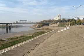 Belaya River in Ufa | |
 Belaya River basin | |
| Origin |
Iremel mountain 54°33′0″N 59°3′0″E / 54.55000°N 59.05000°E |
| Mouth |
Kama, Nizhnekamsk Reservoir 55°53′14″N 53°36′14″E / 55.88722°N 53.60389°ECoordinates: 55°53′14″N 53°36′14″E / 55.88722°N 53.60389°E |
| Basin countries | Bashkortostan, Russia |
| Length | 1,430 km |
| Avg. discharge | 858 m³/s (near Birsk) |
| Basin area | 142,000 km² |
Belaya River (Russian: Бе́лая; Bashkir: Ағиҙел [ä.ʁi̠.ˈðɪ̞l], ![]() pronunciation (help·info); Tatar Cyrillic: Агыйдел, Latin: Ağidel [ˌʌɣiˈdel]) is a river in Bashkortostan, Russian Federation. Its source lies in the south-western Ural Mountains.
pronunciation (help·info); Tatar Cyrillic: Агыйдел, Latin: Ağidel [ˌʌɣiˈdel]) is a river in Bashkortostan, Russian Federation. Its source lies in the south-western Ural Mountains.
Its length is 1,210 km (700 mi).[1]
Settlements along the Belaya include Beloretsk, Sterlitamak, Ufa (at the confluence with the Ufa River), and Birsk. The Belaya flows into the Kama River near Neftekamsk.

Map of the Volga watershed with the Belaya highlighted
References
- ↑ "Definition of Belaya River in English". Oxford Dictionaries. Oxford University Press. Retrieved 21 December 2013.
| Wikimedia Commons has media related to Belaya River. |
| |||||||||||||||||

This article is issued from Wikipedia. The text is available under the Creative Commons Attribution/Share Alike; additional terms may apply for the media files.