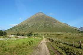
Beinn Dorain
| Beinn Dorain | |
|---|---|
 Beinn Dorain viewed from the south. | |
| Elevation | 1,076 m (3,530 ft)[1] |
| Prominence | 332 m (1,089 ft) |
| Parent peak | Beinn a' Chreachain |
| Listing | Munro, Marilyn |
| Pronunciation | Scottish Gaelic: [peɲ ˈt̪ɔːɾɛɲ] |
| Location | |
| Location | Argyll and Bute, Scotland |
| Range | Bridge of Orchy Hills, Grampian Mountains |
| OS grid | NN325378 |
Beinn Dorain (Gaelic: Beinn Dòbhrain 'hill of the streamlet' or 'hill of the otters'), is a mountain located in the Bridge of Orchy hills of Argyll and Bute, Scotland. It is the subject of Duncan Ban MacIntyre's best known Gaelic poem, "Moladh Beinn Dòbhrainn" (English: "In Praise of Ben Doran"):; MacIntyre had worked as a gamekeeper in these parts.
- An t-urram thar gach beinn
- Aig Beinn Dòbhrain;
- De na chunnaic mi fon ghrèin,
- 'S i bu bhòidhche leam…
English translation:
- Honour beyond each ben
- for Ben Doran;
- Of all I have seen beneath the sun,
- she is the most glorious for me
The mountain is easily accessible from the Bridge of Orchy railway station, from where a path leads up to the bealach separating Beinn Dorain from Beinn an Dothaidh: the two hills are frequently climbed together from this point.
The English composer Ronald Stevenson composed a work for full chorus, chamber chorus, symphony orchestra and chamber orchestra based on MacIntyre's poem, entitled Moladh Beinn Dobhrain (In praise of Ben Dorain) in 2007. In this lyrical, tonal work, Stevenson used the original text and Hugh Macdiarmid's English translation of the verse. It was premiered on 19 January 2008 in Glasgow with the BBC Scottish Symphony Orchestra, Scottish Opera Chorus, Glasgow University Chapel Choir and The Edinburgh Singers.[2]
References
- ↑ "walkhighlands Beinn Dorain". walkhighlands.co.uk. 2013. Retrieved 20 October 2013.
- ↑ Gasser, M., "Ronald Stevenson, Composer-Pianist : An Exegetical Critique from a Pianistic Perspective" (Edith Cowan University Press, Western Australia, 2013)
| Wikimedia Commons has media related to Beinn Dòrain. |
Coordinates: 56°30′09″N 4°43′23″W / 56.50237°N 4.72301°W

