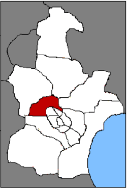
Beichen District
From Wikipedia, the free encyclopedia
| Beichen 北辰 | |
|---|---|
| District | |
| 北辰区 | |
 | |
| Coordinates: 39°13′17″N 117°07′57″E / 39.22139°N 117.13250°ECoordinates: 39°13′17″N 117°07′57″E / 39.22139°N 117.13250°E | |
| Country | People's Republic of China |
| Municipality | Tianjin |
| Township-level divisions |
3 subdistricts 9 towns |
| Elevation | 6 m (20 ft) |
| Time zone | China Standard (UTC+8) |
| Postal code | 300400 |
| Area code(s) | 0022 |
Beichen District (simplified Chinese: 北辰区; traditional Chinese: 北辰區; pinyin: Běichén Qū) is a district of the municipality of Tianjin, People's Republic of China. Before June 1992, the district was named Beijiao District (北郊区), literally "north suburb", reflectings its position in the northern suburbs of Tianjin. As the city expanded, it gradually became part of the urban core and was renamed to Beichen.
The district occupies approximately 478.5 km2 (184.7 sq mi), with a population of 320,000. China National Highway 103 goes through the heart of the district. Beichen District also hosts the North Canal (北运河), a branch of the Hai River.
Administrative divisions
There are 4 subdistricts and 9 towns in the district:[1]
Subdistricts:
- Guoyuanxincun Subdistrict (果园新村街道), Jixianli Subdistrict (集贤里街道), Pudong Subdistrict (普东街道), Jiarongli Subdistrict (佳荣里街道)
Towns:
- Beicang (北仓镇), Tianmu (天穆镇), Shuangjie (双街镇), Shuangkou (双口镇), Qingguang (青光镇), Xiaodian (小淀镇), Yixingbu (宜兴埠镇), Xititou (西堤头镇), Dazhangzhuang (大张庄镇)
References
- ↑ "2011年统计用区划代码和城乡划分代码:北辰区" (in Simplified Chinese). National Bureau of Statistics of the People's Republic of China. Retrieved 2013-08-08.
External links
- Official site (Chinese) (English)
| |||||||||||||||||||||
This article is issued from Wikipedia. The text is available under the Creative Commons Attribution/Share Alike; additional terms may apply for the media files.
