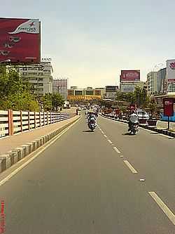
Begumpet
| Begumpet | |
|---|---|
| neighborhood | |
 | |
 Begumpet | |
| Coordinates: 17°26′42″N 78°28′10″E / 17.444865°N 78.469396°ECoordinates: 17°26′42″N 78°28′10″E / 17.444865°N 78.469396°E | |
| Country |
|
| State | Andhra Pradesh |
| District | Hyderabad |
| Metro | Hyderabad |
| Government | |
| • Body | GHMC |
| Languages | |
| • Official | Telugu |
| Time zone | IST (UTC+5:30) |
| PIN | 500 016 |
| Lok Sabha constituency | Secunderabad |
| Vidhan Sabha constituency | Khairtabad |
| Planning agency | GHMC |
Begumpet ("Begum's Place") is a neighborhood in Hyderabad, India.
History
Begumpet is named after the daughter of the sixth Nizam, Basheer Ul-Unnisaa Begum, who received it as part of her wedding dowry when she was married to the second Amir of Paigah Shums ul Umra Amir e Kabir.
About
Begumpet is one of the major commercial and residential suburbs in Secunderabad located to the north of Hussain Sagar lake. The Greenlands flyover connects Begumpet to Panjagutta. Begumpet was an initially a small suburb between Hyderabad and Secunderabad.

Begumpet Airport is a major landmark of the city. The airport is closed for commercial flights after the inauguration of new international airport at Shamshabad and is operational only for training and chartered flights.
Paigah Palace,Gitanjali Senior School, Begumpet Spanish mosque, Hyderabad Public School and Sir Ronald Ross Institute are some important places located in the area. Sanjeevaiah Park is a public park located on the banks of Hussain Sagar.
Transport
Begumpet Railway Station provides rail connectivity to the area. Other MMTS stations in the vicinity include Sanjeevaiah Park and James Street. State-owned APSRTC runs the city bus service, connecting Begumpet to major parts of the city.
External links
| Wikimedia Commons has media related to Begumpet. |