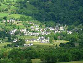
Beaucens
From Wikipedia, the free encyclopedia
| Beaucens | ||
|---|---|---|
 | ||
| ||
 Beaucens | ||
|
Location within Midi-Pyrénées region  Beaucens | ||
| Coordinates: 42°58′39″N 0°03′35″W / 42.9775°N 0.0597°WCoordinates: 42°58′39″N 0°03′35″W / 42.9775°N 0.0597°W | ||
| Country | France | |
| Region | Midi-Pyrénées | |
| Department | Hautes-Pyrénées | |
| Arrondissement | Argelès-Gazost | |
| Canton | Argelès-Gazost | |
| Intercommunality | Vallée d'Argelès-Gazost | |
| Government | ||
| • Mayor (2008–2014) | Stéphanie Lacoste | |
| Area | ||
| • Land1 | 36.82 km2 (14.22 sq mi) | |
| Population (2009) | ||
| • Population2 | 427 | |
| • Population2 Density | 12/km2 (30/sq mi) | |
| INSEE/Postal code | 65077 / 65400 | |
| Elevation |
434–2,637 m (1,424–8,652 ft) (avg. 480 m or 1,570 ft) | |
|
1 French Land Register data, which excludes lakes, ponds, glaciers > 1 km² (0.386 sq mi or 247 acres) and river estuaries. 2 Population without double counting: residents of multiple communes (e.g., students and military personnel) only counted once. | ||
.svg.png)
Beaucens is a commune in the Hautes-Pyrénées department in southwestern France.
Population
| Historical population | ||
|---|---|---|
| Year | Pop. | ±% |
| 1962 | 260 | — |
| 1968 | 247 | −5.0% |
| 1975 | 244 | −1.2% |
| 1982 | 249 | +2.0% |
| 1990 | 309 | +24.1% |
| 1999 | 350 | +13.3% |
| 2006 | 426 | +21.7% |
| 2009 | 427 | +0.2% |
See also
References
| Wikimedia Commons has media related to Beaucens. |
This article is issued from Wikipedia. The text is available under the Creative Commons Attribution/Share Alike; additional terms may apply for the media files.