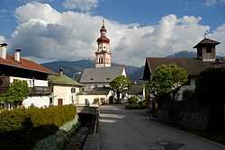
Baumkirchen
From Wikipedia, the free encyclopedia
| Baumkirchen | ||
|---|---|---|
 | ||
| ||
 Baumkirchen | ||
Location in the district
| ||
| Coordinates: 47°17′59″N 11°33′00″E / 47.29972°N 11.55000°ECoordinates: 47°17′59″N 11°33′00″E / 47.29972°N 11.55000°E | ||
| Country | Austria | |
| State | Tyrol | |
| District | Innsbruck Land | |
| Government | ||
| • Mayor | Josef Schindl (ÖVP) | |
| Area | ||
| • Total | 4.0 km2 (1.5 sq mi) | |
| Elevation | 593 m (1,946 ft) | |
| Population (1 January 2013)[1] | ||
| • Total | 1,151 | |
| • Density | 290/km2 (750/sq mi) | |
| Time zone | CET (UTC+1) | |
| • Summer (DST) | CEST (UTC+2) | |
| Postal code | 6121 | |
| Area code | 05224 | |
| Vehicle registration | IL | |
| Website | www.baumkirchen.tirol.gv.at | |
Baumkirchen is a community in the district of Innsbruck Land. It lies in the Inn Valley north of the Inn River on a batter of the Gnadenwald terrace. The village can be reached via the Inn Valley Motorway.
Population
| Historical population | ||
|---|---|---|
| Year | Pop. | ±% |
| 1869 | 232 | — |
| 1880 | 260 | +12.1% |
| 1890 | 246 | −5.4% |
| 1900 | 256 | +4.1% |
| 1910 | 269 | +5.1% |
| 1923 | 292 | +8.6% |
| 1934 | 431 | +47.6% |
| 1939 | 416 | −3.5% |
| 1951 | 512 | +23.1% |
| 1961 | 543 | +6.1% |
| 1971 | 713 | +31.3% |
| 1981 | 870 | +22.0% |
| 1991 | 935 | +7.5% |
| 2001 | 1,085 | +16.0% |
| 2011 | 1,144 | +5.4% |
References
External links
- Town History (German)
- Municipality Baumkirchen: Official website of the municipality in the Hall-Wattens region
| Wikimedia Commons has media related to Baumkirchen. |
This article is issued from Wikipedia. The text is available under the Creative Commons Attribution/Share Alike; additional terms may apply for the media files.

