Baulne-en-Brie
| Baulne-en-Brie | |
|---|---|
 | |
 Baulne-en-Brie | |
|
Location within Picardy region  Baulne-en-Brie | |
| Coordinates: 48°59′16″N 3°36′53″E / 48.9878°N 3.6147°ECoordinates: 48°59′16″N 3°36′53″E / 48.9878°N 3.6147°E | |
| Country | France |
| Region | Picardy |
| Department | Aisne |
| Arrondissement | Château-Thierry |
| Canton | Condé-en-Brie |
| Intercommunality | Condé en Brie |
| Government | |
| • Mayor (2008–2014) | Bruno Lahouati |
| Area | |
| • Land1 | 18.89 km2 (7.29 sq mi) |
| Population (2010) | |
| • Population2 | 288 |
| • Population2 Density | 15/km2 (39/sq mi) |
| INSEE/Postal code | 02053 / 02330 |
| Elevation |
82–243 m (269–797 ft) (avg. 100 m or 330 ft) |
|
1 French Land Register data, which excludes lakes, ponds, glaciers > 1 km² (0.386 sq mi or 247 acres) and river estuaries. 2 Population without double counting: residents of multiple communes (e.g., students and military personnel) only counted once. | |
Baulne-en-Brie is a French commune in the department of Aisne in the Picardy region of northern France.
Geography
Baulne-en-Brie is located some 15 km east by south-east of Château-Thierry and 20 km west by south-west of Épernay. It can be accessed by the D4 road from Condé-en-Brie in the west through the heart of the commune and the village and continuing east to Le Breuil. There is also a country road from La Chapelle-Monthodon in the north. The south-eastern border of the commune is part of the border between the departments of Aisne and Marne. There are three ham;lets in the commune other than the village: Montchevret, Grande Fontaine, and Romandie. There are extensive forests in the north, centre, south-east and south of the commune with the rest of the area being farmland.
The Verdonnelle stream flows north-west through the southern part of the commune passing near the hamlet of Romandie and continuing north-west out of the commune. The Surmelin stream flows from the south-east passing through the village and continuing north-west to join the Marne near Mézy-Moulins.[1]
Neighbouring communes and villages[1]
 |
Saint-Agnan | La Chapelle-Monthodon | Igny-Comblizy | |
| Condé-en-Brie | |
Le Breuil | ||
| ||||
| | ||||
| Montlevon | Verdon |
Administration
List of Successive Mayors of Baulne-en-Brie
| From | To | Name | Party | Position |
|---|---|---|---|---|
| 2001 | 2008 | Gilles Hiernard | DVD | |
| 2008 | 2014 | Bruno Lahouati[2] |
(Not all data is known)
Demography
In 2010, the commune had 288 inhabitants. The evolution of the number of inhabitants is known through the population censuses conducted in the commune since 1793. From the 21st century, a census of municipalities with fewer than 10,000 inhabitants is held every five years, unlike larger towns that have a sample survey every year.[Note 1]
| 1793 | 1800 | 1806 | 1821 | 1831 | 1836 | 1841 | 1846 | 1851 |
|---|---|---|---|---|---|---|---|---|
| 428 | 515 | 572 | 589 | 637 | 628 | 673 | 730 | 724 |
| 1856 | 1861 | 1866 | 1872 | 1876 | 1881 | 1886 | 1891 | 1896 |
|---|---|---|---|---|---|---|---|---|
| 702 | 639 | 633 | 562 | 537 | 504 | 512 | 527 | 510 |
| 1901 | 1906 | 1911 | 1921 | 1926 | 1931 | 1936 | 1946 | 1954 |
|---|---|---|---|---|---|---|---|---|
| 442 | 420 | 440 | 380 | 371 | 334 | 347 | 299 | 268 |
| 1962 | 1968 | 1975 | 1982 | 1990 | 1999 | 2006 | 2007 | 2010 |
|---|---|---|---|---|---|---|---|---|
| 256 | 220 | 194 | 243 | 219 | 238 | 284 | 290 | 288 |
Sources : Ldh/EHESS/Cassini until 1962, INSEE database from 1968 (population without double counting and municipal population from 2006)
Economy
Baulne-en-Brie is an agricultural and wine-producing village and a part of the Appellation d'origine contrôlée (AOC) zone for "Champagne of Aisne".
Sites and Monuments
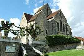
The Church of Saint Bartholomew has been a historical monument since 1920 and has one of the last wooden ceilings with alternating grain slats in the world. The ceiling and the pulpit are classified as Historical Monuments.

- Place Daniel Beaucreux in front of the church. In memory of the men and women of the Canton of Condé-en-Brie and the region who experienced deportation and death in the concentration camps. Marked: "Dead in Deportation, alive in our memories".
- In the main street the Public laundry has been decorated on the theme of the fable "The dairy and milk jug".
- The area around the hamlet of Romandie is called "Little Switzerland of Condé" and gives access to the Verdonnelle valley.
- On the road to Saint-Agnan, a directional table opposite the Chemin de Glapiers offers an outstanding view of the Surmelin valley.
See also
- Communes of the Aisne department
- Baulne-en-Brie on the National Geographic Institute website (French)
- Official site of the Union for initiative of the canton of Condé-en-Brie (French)
- Baulne-en-Brie on the INSEE website (French)
- Official website for Baulne-en-Brie (French)
- Page for La Roquette Prisons
- INSEE (French)
Notes and references
Notes
- ↑ At the beginning of the 21st century, the methods of identification have been modified by law No. 2002-276 of 27 February 2002 , the so-called "law of local democracy" and in particular Title V "census operations" which allow, after a transitional period running from 2004 to 2008, the annual publication of the legal population of the different French administrative districts. For municipalities with a population greater than 10,000 inhabitants, a sample survey is conducted annually, the entire territory of these municipalities is taken into account at the end of the period of five years. The first "legal population" after 1999 under this new law came into force in 1 January 2009 and was based on the census of 2006.
References
- ↑ 1.0 1.1 Google Maps
- ↑ General Council of Aisne consulted on 7 July 2008
| Wikimedia Commons has media related to Baulne-en-Brie. |