Barton in Fabis
From Wikipedia, the free encyclopedia
Coordinates: 52°53′N 1°13′W / 52.89°N 1.22°W

| Barton in Fabis | |
 Barton in Fabis |
|
 Barton in Fabis | |
| OS grid reference | SK5232 |
|---|---|
| District | Rushcliffe |
| Shire county | Nottinghamshire |
| Region | East Midlands |
| Country | England |
| Sovereign state | United Kingdom |
| Post town | NOTTINGHAM |
| Postcode district | NG11 |
| Dialling code | 0115 |
| Police | Nottinghamshire |
| Fire | Nottinghamshire |
| Ambulance | East Midlands |
| EU Parliament | East Midlands |
| |
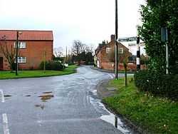
Barton in Fabis is a village and civil parish in the Rushcliffe district of Nottinghamshire. It has a population of about 250. The village is just south of Nottingham, being on the other side of the River Trent from Attenborough.
A ferry, Barton Ferry, used to cross the River Trent to the Attenborough side near to the mouth of the River Erewash. A ferry has crossed the River Trent at this point since before 1774.[1]

A Ferry near to Barton in Fabis 1949
The name originates from an older name, "Barton in the Beans" (Fabis being Latin for 'bean', in the abl. plural, one bean = una faba), apparently referring to the beans grown in the village. This name was also used for a Leicestershire village, Barton in the Beans, which has retained its name.[2]
See also
References
- ↑ Chapman’s Map of Nottinghamshire 1774. Nottinghamshire Library ISBN 0-902751-46-8.
- ↑ Ekwall, E. (1940), The concise dictionary of English place-names, 2nd ed. Oxford University Press
External links
-
 Media related to Barton in Fabis at Wikimedia Commons
 - Barton [-in-Fabis] in the Domesday Book
This article is issued from Wikipedia. The text is available under the Creative Commons Attribution/Share Alike; additional terms may apply for the media files.