Barnesville, Ohio
| Barnesville, Ohio | |
|---|---|
| Village | |
 | |
| Motto: "Where History Meets Progress" | |
 | |
| Coordinates: 39°59′17″N 81°10′32″W / 39.98806°N 81.17556°WCoordinates: 39°59′17″N 81°10′32″W / 39.98806°N 81.17556°W | |
| Country | United States |
| State | Ohio |
| County | Belmont |
| Government | |
| • Mayor | Ron Bischof |
| Area[1] | |
| • Total | 1.95 sq mi (5.05 km2) |
| • Land | 1.94 sq mi (5.02 km2) |
| • Water | 0.01 sq mi (0.03 km2) |
| Elevation[2] | 1,270 ft (387 m) |
| Population (2010)[3] | |
| • Total | 4,193 |
| • Estimate (2012[4]) | 4,145 |
| • Density | 2,161.3/sq mi (834.5/km2) |
| Time zone | Eastern (EST) (UTC-5) |
| • Summer (DST) | EDT (UTC-4) |
| ZIP code | 43713 |
| Area code(s) | 740 |
| FIPS code | 39-03926[5] |
| GNIS feature ID | 1064381[2] |
| Website | Barnesville Ohio |
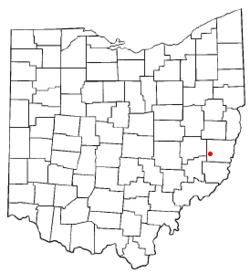
Barnesville is a village in Belmont County, Ohio, United States. It is located in the central portion of Warren Township in Belmont County. It is part of the Wheeling, West Virginia Metropolitan Statistical Area. The population was 4,193 at the 2010 census.
History
The town was named after James Barnes, a settler.[6] Barnesville was described in 1833 as having six stores and a steam mill.[7]
Geography
Barnesville is located at 39°59′17″N 81°10′32″W / 39.988129°N 81.175483°W.[8]
According to the United States Census Bureau, the village has a total area of 1.95 square miles (5.05 km2), of which, 1.94 square miles (5.02 km2) is land and 0.01 square miles (0.03 km2) is water.[1]
Demographics
2010 census
As of the census[3] of 2010, there were 4,193 people, 1,763 households, and 1,114 families residing in the village. The population density was 2,161.3 inhabitants per square mile (834.5 /km2). There were 2,011 housing units at an average density of 1,036.6 per square mile (400.2 /km2). The racial makeup of the village was 97.0% White, 0.9% African American, 0.1% Native American, 0.3% Asian, and 1.6% from two or more races. Hispanic or Latino of any race were 0.6% of the population.
There were 1,763 households of which 29.4% had children under the age of 18 living with them, 42.4% were married couples living together, 15.7% had a female householder with no husband present, 5.1% had a male householder with no wife present, and 36.8% were non-families. 32.0% of all households were made up of individuals and 16.3% had someone living alone who was 65 years of age or older. The average household size was 2.28 and the average family size was 2.82.
The median age in the village was 41.4 years. 21.4% of residents were under the age of 18; 8.9% were between the ages of 18 and 24; 23.9% were from 25 to 44; 25.5% were from 45 to 64; and 20.5% were 65 years of age or older. The gender makeup of the village was 46.2% male and 53.8% female.
2000 census
As of the census[5] of 2000, there were 4,225 people, 1,769 households, and 1,119 families residing in the village. The population density was 2,196.6 people per square mile (849.6/km2). There were 1,964 housing units at an average density of 1,021.1 per square mile (395.0/km2). The racial makeup of the village was 98.41% White, 0.71% African American, 0.07% Native American, 0.17% Asian, and 0.64% from two or more races. Hispanic or Latino of any race were 0.26% of the population.
There were 1,769 households out of which 28.9% had children under the age of 18 living with them, 45.5% were married couples living together, 13.9% had a female householder with no husband present, and 36.7% were non-families. 33.7% of all households were made up of individuals and 18.5% had someone living alone who was 65 years of age or older. The average household size was 2.30 and the average family size was 2.94.
In the village the population was spread out with 23.6% under the age of 18, 8.3% from 18 to 24, 25.5% from 25 to 44, 21.7% from 45 to 64, and 20.8% who were 65 years of age or older. The median age was 40 years. For every 100 females there were 82.0 males. For every 100 females age 18 and over, there were 77.4 males.
The median income for a household in the village was $23,925, and the median income for a family was $31,927. Males had a median income of $25,098 versus $16,119 for females. The per capita income for the village was $14,105. About 21.2% of families and 22.1% of the population were below the poverty line, including 35.1% of those under age 18 and 14.6% of those age 65 or over.
Art and Culture
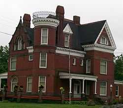
The Belmont County Victorian Mansion Museum is located in Barnesville. The museum includes twenty-six rooms restored to the Victorian era.[9]
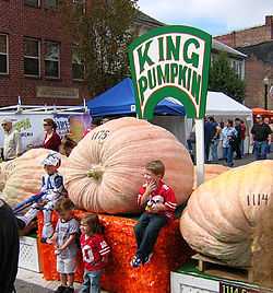
The village is the host of the Barnesville Pumpkin Festival every September, attracting tourists from the area.
Education
The village of Barnesville is served by the Barnesville Exempted Village School District. The village's schools saw a renovation in 2002 to improve and expand classroom learning and appearances.
There are three main schools in the village: Barnesville Elementary School, Barnesville Middle School, and Barnesville High School.
Also located in the village is Olney Friends School, a small co-educational boarding high school affiliated with the Religious Society of Friends (Quakers).
Another school in the village is the Barnesville Independent Elementary School. The school teaches students from K-8.
Notable residents
- Elisha Gray - claimant to the title of inventor of the telephone
- Isaac Charles Parker - The Hanging Judge
- Wilson Shannon - First native born Ohio Governor
- George Shannon (explorer) - Member of Lewis and Clark Expedition
Gallery
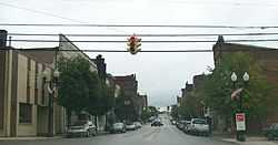
-

Barnesville Historic District, view of downtown facing East.
-
The Bradfield Building, on the north eastern corner of Main and Chestnut Streets.
-
Belmont County Victorian Mansion Museum in Barnesville, built in 1893.
-

The Barnesville B&O Railroad Depot, built in 1916.
References
- ↑ 1.0 1.1 "US Gazetteer files 2010". United States Census Bureau. Retrieved 2013-01-06.
- ↑ 2.0 2.1 "US Board on Geographic Names". United States Geological Survey. 2007-10-25. Retrieved 2008-01-31.
- ↑ 3.0 3.1 "American FactFinder". United States Census Bureau. Retrieved 2013-01-06.
- ↑ "Population Estimates". United States Census Bureau. Retrieved 2013-06-17.
- ↑ 5.0 5.1 "American FactFinder". United States Census Bureau. Retrieved 2008-01-31.
- ↑ "Profile for Barnesville, Ohio, OH". ePodunk. Retrieved 2012-07-07.
- ↑ Kilbourn, John (1833). "The Ohio Gazetteer, Or a Topographical Dictionary". Scott and Wright. p. 84. Retrieved 12 December 2013.
- ↑ "US Gazetteer files: 2010, 2000, and 1990". United States Census Bureau. 2011-02-12. Retrieved 2011-04-23.
- ↑ "Belmont County Victorian Mansion Museum". The Belmont County Historical Society. Retrieved 2012-06-07.
External links
| Wikimedia Commons has media related to Barnesville. |
| ||||||||||||||||||||||||||


