Barmulloch
From Wikipedia, the free encyclopedia
Coordinates: 55°53′01″N 4°12′22″W / 55.883544°N 4.206162°W
 Barmulloch (Barr a' Mhullaich in Gaelic) is a district in the Scottish city of Glasgow. It is situated north of the River Clyde. Formerly rural, it was developed as a post war overspill housing area, largely featuring Prefabricated housing. Barmulloch shares the Red Road complex of multi-storey flats with the neighbouring district of Balornock.

| Barmulloch | |
| Scottish Gaelic: Barr a' Mhullaich | |
 Barmulloch | |
| OS grid reference | NS621678 |
|---|---|
| Council area | Glasgow City Council |
| Lieutenancy area | Glasgow |
| Country | Scotland |
| Sovereign state | United Kingdom |
| Post town | GLASGOW |
| Postcode district | G21 |
| Dialling code | 0141 |
| Police | Scottish |
| Fire | Scottish |
| Ambulance | Scottish |
| EU Parliament | Scotland |
| UK Parliament | Glasgow North East |
| Scottish Parliament | Glasgow Provan |

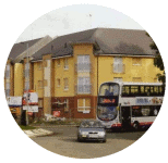
modern flats in Barmulloch
Barmulloch is currently going through a huge change which includes demolition of tenement housing making way for new houses with driveways and private gardens. These developments are followed closely by Scottish charity Barmulloch Community Development Company who own the old Barmulloch Tenants Hall in Quarrywood Road and currently lease the former Church Hall in Quarrywood Avenue for local community functions and events.

The Red Road flats
This article is issued from Wikipedia. The text is available under the Creative Commons Attribution/Share Alike; additional terms may apply for the media files.