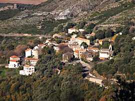
Barbaggio
| Barbaggio Barbaghju | |
|---|---|
 | |
 Barbaggio | |
|
Location within Corsica region  Barbaggio | |
| Coordinates: 42°41′05″N 9°22′25″E / 42.68470°N 9.37350°ECoordinates: 42°41′05″N 9°22′25″E / 42.68470°N 9.37350°E | |
| Country | France |
| Region | Corsica |
| Department | Haute-Corse |
| Arrondissement | Bastia |
| Canton | La Conca-d'Oro |
| Government | |
| • Mayor (2008–2014) | Olivier Mei |
| Area | |
| • Land1 | 10.86 km2 (4.19 sq mi) |
| Population (2008) | |
| • Population2 | 216 |
| • Population2 Density | 20/km2 (52/sq mi) |
| INSEE/Postal code | 2B029 / 20253 |
| Elevation |
7–940 m (23–3,084 ft) (avg. 300 m or 980 ft) |
|
1 French Land Register data, which excludes lakes, ponds, glaciers > 1 km² (0.386 sq mi or 247 acres) and river estuaries. 2 Population without double counting: residents of multiple communes (e.g., students and military personnel) only counted once. | |
Barbaggio is a commune in the Haute-Corse department of France on the island of Corsica. It is known for its wine, its scenery, and the prehistoric site of Strette.
Geography
Barbaggio, a very small commune, is named for the village of Barbaggio, which sits on an upland plateau at the base of Cap Corse on the southwest slopes of 960 metres (3,150 ft) Serra di Pigno. In times of conflict it controls the Col de Teghine, a pass through the Serra mountains, at a 536-metre (1,759 ft) elevation, leading to Bastia, 10 kilometres (6 mi) away. The village is reached by a winding Route D81, which crosses the peninsula and goes over the pass. Barbaggio has a fine view of the Golfe de St-Florent but does not itself border on the water. It is traditionally a village of the region of Nebbio.
The plateau, which is drained by small streams, such as the Ruisseau de Lucitello, gives to the village its chief economic resource, 45 hectares (110 acres) of grapevines. The commune is known for its fine wine. Of the remainder of the 1,086 ha (2,680 acres), 610 ha (1,500 acres) are woods. Barbaggio shares with nearby Oletta a nature reserve of 32 ha (79 acres).[1]
Economy
Viticulture is the chief industry of Barbaggio. Vines have been grown on terraced hillsides there and in most other villages of the wine-making region of Cap Corse since antiquity, possibly prehistory. The wine industry of France in recent times is regulated by a governmental system of certification, the Appellation d'origine contrôlée (AOC), which specifies where and under what conditions the grapes for its labels can be grown. Barbaggio is warranted to make the following labels:
These are high-quality light table wines of minimal aging and short life made from grapes grown by several land-owners of the region.
Prehistory
The rivulets that drain the plateau beneath Barbaggio and nearby Patrimonio gather into a single stream, the Ruisseau la Strutta or Rivière de la Strutta, "Strutta Stream", which flowing between 200-metre (660 ft) cliffs crosses a short alluvial plain and empties into the Golfe-de-St.-Florent. Route D81 leaving Saint-Florent bears northeast along the alluvium and turns inland through the gorge. Just over the Barbaggio border at the base of a cliff is the prehistoric Abri de Strette, "Strette Shelter", where strette is "narrow place", one of the oldest continuously occupied sites of Corsica.
The material of the bottom layer has been carbon-dated to 9140±300 BP, about 7000 BC, well into the Pre-Neolithic. It contains shell middens and the bones of small animals, such as Prolagus sardus (some say corsicanus), believed extinct, as well as a lithic assemblage. Chemical analysis of the stones identifies them as non-Corsican. This level is believed to have been a seasonal hunter-gatherer site of non-Corsicans arriving by boat.[5]
The Early Neolithic, starting about 6000 BC, is identified by sherds of Cardial Ware. Subsequent layers indicate a continuous occupation until the end of the Bronze Age; i.e., this was an indigenous village commanding the route to the plateau and the pass. It was abandoned at the start of the Iron Age but was sporadically occupied after.
History
In the Middle Ages Barbaggio − that is, Barbaio − belonged to the Diocese of Nebbio, Latin Nebulensis, "cloudy", which comprised a section of northwest Corsica and the southwest coast of Cap Corse. These facts are attested by the Cartulary[6] of Nebbio, a fragment of a 13th-century collection of documents published by the bishops of Nebbio concerning the notarization of land titles from the 10th to the 13th centuries AD. One of the notaries is Johannes de S. Martino de Barbaio, a priest. The language of the document shows that the Corsican language already had evolved from Latin.[7]
Population
| Historical population | ||
|---|---|---|
| Year | Pop. | ±% |
| 1962 | 69 | — |
| 1968 | 73 | +5.8% |
| 1975 | 75 | +2.7% |
| 1982 | 78 | +4.0% |
| 1990 | 111 | +42.3% |
| 1999 | 164 | +47.7% |
| 2008 | 216 | +31.7% |
See also
References
- ↑ Brunet, Roger. "Barbaggio (Barbaghju)". France, le trésor des régions. Retrieved 2008-05-10. (French)
- ↑ "AOC Muscat du Cap Corse". Find the Vine. 1997. Retrieved 2008-05-14. (English)
- ↑ "AOC Patrimonio". Find the Vine. 1997. Retrieved 2008-05-14. (English)
- ↑ "AOC Vin de Corse". Find the Vine. 1997. Retrieved 2008-05-14. (English)
- ↑ "Préhistoire". Histoire du Nebbiu. 2001. Retrieved 2008-05-11. (French)
- ↑ "cartulary". The American Heritage Dictionary of the English Language: Fourth Edition. 2000. Retrieved 2008-05-15. (English).
- ↑ Scalfati, Silio P. P. "Latin et langue vernaculaire dans les actes notariés corses XIe-XVe siècle". Éditions en ligne de l'École des chartes. Retrieved 2008-05-15. (French).
| Wikimedia Commons has media related to Barbaggio. |