Baie-Johan-Beetz, Quebec
| Baie-Johan-Beetz | |
|---|---|
| Municipality | |
 | |
 Baie-Johan-Beetz | |
| Coordinates: 50°17′N 62°48′W / 50.283°N 62.800°WCoordinates: 50°17′N 62°48′W / 50.283°N 62.800°W[1] | |
| Country |
|
| Province |
|
| Region | Côte-Nord |
| RCM | Minganie |
| Constituted | 1 January 1966 |
| Named for | Johan Beetz |
| Government[2] | |
| • Mayor | Martin Côté |
| • Federal riding | Manicouagan |
| • Prov. riding | Duplessis |
| Area[2][3] | |
| • Total | 525.40 km2 (202.86 sq mi) |
| • Land | 360.28 km2 (139.10 sq mi) |
| Elevation | 10 m (30 ft) |
| Population (2011)[3] | |
| • Total | 81 |
| • Density | 0.2/km2 (0.5/sq mi) |
| • Pop 2006-2011 |
|
| • Dwellings | 46 |
| Time zone | Within the AST legislated time zone boundary but observes EST [4] (UTC-5) |
| • Summer (DST) | EDT (UTC-4) |
| Postal code(s) | G0G 1B0 |
| Area code(s) | 418 and 581 |
| Highways |
|
| Website | www.baiejohanbeetz.qc.ca |
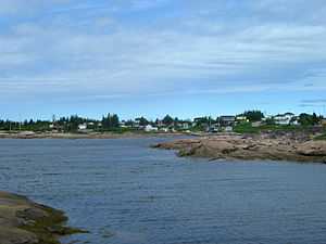
Baie-Johan-Beetz is a municipality and village in the Côte-Nord region of the province of Quebec in Canada, located some 60 kilometres (37 mi) east of Havre-Saint-Pierre. It has the lowest population of all incorporated places in the Côte-Nord region.
History

The first settlers came from the Magdalen Islands, and one family came from Berthier-sur-Mer. The place was originally identified as "Piastre Bay", from the Innu expression piashite-pets, meaning "there where the water passes over/on top", or possibly originating from the word piashtibé, meaning "dry bay" or "where the water rises", which is a reference to the local bay that during low tide runs dry.[1]
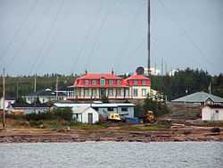
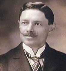
But the bay's name was spelled in a variety of ways, including Piashti Bay, Pillage Bay, Baie-de-Pillage, Piastibe, Piashte Bay, and Piestebé. Perhaps for this reason, its residents expressed a desire to change the village's name to Baie-Johan-Beetz in 1910. Johan Beetz (1874-1949) was a Belgian naturalist, who lived in the Bay from 1897 to 1922. He had moved there to breed fur animals, particularly foxes, and built a luxurious manor that residents today call le château (the castle). The bay was renamed in 1914, but the name was not officially adopted until 1965 when the place was incorporated.[1]
In 1996, Highway 138 was extended to Baie-Johan-Beetz, linking it to the municipality of Havre-Saint-Pierre and thereby breaking its isolation.[1]
Demographics
Population trend:[5]
- Population in 2011: 81 (2006 to 2011 population change: -14.7 %)
- Population in 2006: 95
- Population in 2001: 89
- Population in 1996: 85
- Population in 1991: 107
Private dwellings occupied by usual residents: 35 (total dwellings: 46)
Mother tongue:
- English as first language: 0%
- French as first language: 100%
- English and French as first language: 0%
- Other as first language: 0%

Climate
| Climate data for Baie-Johan-Beetz | |||||||||||||
|---|---|---|---|---|---|---|---|---|---|---|---|---|---|
| Month | Jan | Feb | Mar | Apr | May | Jun | Jul | Aug | Sep | Oct | Nov | Dec | Year |
| Record high °C (°F) | 8.9 (48) |
6.5 (43.7) |
11 (52) |
16.5 (61.7) |
32 (90) |
29 (84) |
28.5 (83.3) |
29 (84) |
28.3 (82.9) |
20.6 (69.1) |
13.3 (55.9) |
8.3 (46.9) |
32 (90) |
| Average high °C (°F) | −8.3 (17.1) |
−7.2 (19) |
−1.5 (29.3) |
4 (39) |
10.3 (50.5) |
15.7 (60.3) |
19.3 (66.7) |
18.8 (65.8) |
14 (57) |
7.8 (46) |
1.7 (35.1) |
−5.1 (22.8) |
5.8 (42.4) |
| Daily mean °C (°F) | −13.7 (7.3) |
−12.8 (9) |
−6.6 (20.1) |
0.2 (32.4) |
6 (43) |
11.2 (52.2) |
14.9 (58.8) |
14.2 (57.6) |
9.7 (49.5) |
4.2 (39.6) |
−1.9 (28.6) |
−9.7 (14.5) |
−1.3 (29.7) |
| Average low °C (°F) | −19.1 (−2.4) |
−18.4 (−1.1) |
−11.7 (10.9) |
−3.7 (25.3) |
1.6 (34.9) |
6.6 (43.9) |
10.4 (50.7) |
9.7 (49.5) |
5.3 (41.5) |
0.6 (33.1) |
−5.4 (22.3) |
−14.2 (6.4) |
−3.2 (26.2) |
| Record low °C (°F) | −37.8 (−36) |
−38 (−36) |
−35 (−31) |
−23.5 (−10.3) |
−11.1 (12) |
−2.5 (27.5) |
2.8 (37) |
−0.6 (30.9) |
−5.6 (21.9) |
−12.2 (10) |
−21.5 (−6.7) |
−33.9 (−29) |
−38 (−36) |
| Precipitation mm (inches) | 72.4 (2.85) |
40.4 (1.591) |
60.5 (2.382) |
56.8 (2.236) |
90.8 (3.575) |
99.4 (3.913) |
101.4 (3.992) |
95.3 (3.752) |
103.9 (4.091) |
105.7 (4.161) |
89.7 (3.531) |
73.3 (2.886) |
989.6 (38.961) |
| Source: Environment Canada[6] | |||||||||||||
Transports
The city is served by the Baie-Johan-Beetz Seaplane Base (SPB) (IATA: YBJ).
References
- ↑ 1.0 1.1 1.2 1.3 "Baie-Johan-Beetz (Municipalité)" (in French). Commission de toponymie du Québec. Retrieved 2010-09-09.
- ↑ 2.0 2.1 Ministère des Affaires municipales, des Régions et de l'Occupation du territoire - Répertoire des municipalités: Baie-Johan-Beetz
- ↑ 3.0 3.1 "Baie-Johan-Beetz Census Profile". Statistics Canada, 2011 Census of Population. 8 February 2012. Retrieved 2012-05-27.
- ↑ National Research Council Canada - Time Zones & Daylight Saving Time
- ↑ Statistics Canada: 1996, 2001, 2006, 2011 census
- ↑ Environment Canada Canadian Climate Normals 1971–2000, accessed 14 July 2010
| Wikimedia Commons has media related to Baie-Johan-Beetz. |
 |
Lac-Jérôme |  | ||
| Havre-Saint-Pierre | |
Aguanish | ||
| ||||
| | ||||
| Gulf of Saint Lawrence (Jacques Cartier Strait) / L'Île-d'Anticosti |
| |||||||||||||||||