Bahía Mansa
From Wikipedia, the free encyclopedia
| Bahía Mansa | |
|---|---|
 | |
| Coordinates: 40°35′4″S 73°44′9″W / 40.58444°S 73.73583°WCoordinates: 40°35′4″S 73°44′9″W / 40.58444°S 73.73583°W | |
| Region | Los Lagos |
| Province | Osorno |
| Municipality | San Juan de la Costa |
| Commune | San Juan de la Costa |
| Government | |
| • Type | Municipal |
| • Alcade | Bernardo Candia Henríquez (DC) |
| Elevation | 10 m (30 ft) |
| Population (2002[1]) | |
| • Total | 902 (including Maicolpue) |
| Time zone | Chilean Standard (UTC-4 hours) |
| • Summer (DST) | Chilean Daylight (UTC-3 hours) |
| Area code(s) | Country + town = 56 + 64 |
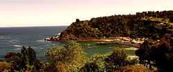
Bahía Mansa is a settlement and bay located at coast of Osorno Province, southern Chile. It is the main port between Corral Bay and Maullín River and the only port of Osorno Province. The towns economy revolves around tourism and fishing. Bahía Mansa is the namesake of the Bahía Mansa Metamorphic Complex.
References
- ↑ Chile: Ciudades, pueblos, aldeas y caseríos, Instituto nacional de estadísticas, June, 2005, retrieved January 10, 2014
This article is issued from Wikipedia. The text is available under the Creative Commons Attribution/Share Alike; additional terms may apply for the media files.