Badli
Badli is one of the oldest and biggest Yadav [1] dominated village in Delhi. History says that whenever Delhi was attacked Badli used to face the attack and used to be the camp of the invaders.
known personality
- Tek chand
- Ami chand (ex pardhan)
Ami chand pardhan was a known social worker and one of the biggest farmer in peas cultivation.he was ex pardhan of badli village from 1971 till urbanisation of villages.
work done by ami chand
- senior secondary school (one of the biggest school in delhi) contribute 12 acres.
- primary school (4 acre)
- women healthcare center.
- distribute 200 bigh land to the landless farmers in '20 point program'.
- distribute 345 plot to landless people.
- veterinary hospital.
facility
- 2 metro stations (badli moad, badli)
- railway station.
- post office.
- hospital.
- bank.
- Police Station
Overview

Badli is now an urban village having lost its most of the land through govt. acquisition for the development of Rohini Sub City. Badli now has 71% industrial concentration which provides the livelihood of the local residents. Badli boasts of a railway station, DSIIDC industrial area and recently it has been gifted with a metro rail in the third phase.
Badli now is an assembly constituency being represented by the two time councillor and present MLA sh. Devender yadav. The constituency consists of two urban villages namely Badli & Samaypur three rural villages i.e. Libaspur, Siraspur and Bhalswa.
It has two resettlement colonies Bhalswa & Jahangirpuri and around 32 unauthorised colonies and a few jhuggi jhopri (J.J.) clusters. With Delhi college of Engineering (DCE) now Delhi Technical University (DTU) of Delhi State, nearby in revenue estate of Samaypur and Shahbad Daulatpur and an ITI in Jahangirpuri the infrastructure needs a serious boost.
Badli Industrial Area
Badli Industrial Area is one of the important Industrial areas, of North Delhi Badli village is an urban village of North West Delhi located near Delhi Technical University (formerly Dellhi College of Engg. or DCE). Badli is nearby NH 1 with Rohini on east, Samaypur on west, the outer ring road forms the north boundary.,[2] India. Adjacent to this is Samaypur, which is also an industrial area of Delhi.
Badli Village
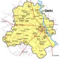
Badli is a Village in North West Delhi Tehsil in North West Delhi District of Delhi State, India. it is located 9 km towards East from District head quarters Kanjhawala. 5 km from North West Delhi. 15 km from State capital Delhi.[3]
Badli Pin code is 110042 and postal head office is Samai Pur.
Prashant Vihar (2 km), Siraspur (3 km), Maurya Enclave (4 km), Rohini Sector-7 (4 km), Rohini Sector 5 (4 km) are the nearby Villages to Badli. Badli is surrounded by North Delhi Tehsil towards East, West Delhi Tehsil towards South, Central Delhi Tehsil towards East, Loni Tehsil towards East.
Loni, Delhi, Bahadurgarh, Noida are the nearby Cities to Badli.
This Place is in the border of the North West Delhi District and North Delhi District. North Delhi District North Delhi is East towards this place. Also it is in the Border of other district North East Delhi.
References
Coordinates: 28°35′N 76°49′E / 28.583°N 76.817°E