Badlands

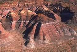
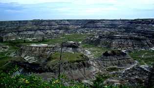
Badlands are a type of dry terrain where softer sedimentary rocks and clay-rich soils have been extensively eroded by wind and water.[1] They are characterized by steep slopes, minimal vegetation, lack of a substantial regolith, and high drainage density.[2] They can resemble malpaís, a terrain of volcanic rock. Canyons, ravines, gullies, hoodoos and other such geological forms are common in badlands. They are often difficult to navigate by foot. Badlands often have a spectacular color display that alternates from dark black/blue coal stria to bright clays to red scoria.
Composition
Badlands are partially characterized by their thin to nonexistent regolith layers. The regolith profile of badlands in arid climates are likely to resemble one another.[2] In these regions, the upper layer (~1–5 cm) is typically composed of silt, shale, and sand (a byproduct of the weathered shale). This layer can either form a compact crust or a looser, more irregular aggregation of "popcorn" fragments. Located beneath the top layer is a sublayer (~5–10 cm), below which can be found a transitional shard layer (~10–40 cm), largely formed of loose disaggregated shale chips, which in turn eventually gives way to a layer of unweathered shale. Badlands such as those found in the Mancos Shale, the Brule Formation, the Chadron Formation, and the Dinosaur Badlands can be generally said to fit this profile.
In less arid regions, however, the regolith profile can vary considerably. Some badlands have no regolith layer whatsoever, capping instead in bare rock such as sandstone. Others have a regolith with a clay veneer, and still others have a biological crust of algae or lichens.[2]
While badlands often lack a significant regolith, they also oftentimes lack much vegetation. The lack of vegetation could very well be a result of the lack of a substantial regolith.[3]
Formation
The formation of badlands is a result of two aspects, deposition and erosion. The process of deposition describes the accumulation, over time, of layers of mineral material. Different environments such as seas, rivers, or tropical zones, deposit different sorts of clays, silts, and sand. For instance, the badlands formations in Badlands National Park, South Dakota, underwent a 47-million year period of deposition which spanned three major geologic periods (the Cretaceous Period, the Late Eocene, and the Oligocene Epochs), resulting in clear, distinct layers of sediment [4] which serve as a dramatic display of the law of superposition. Once the deposited sediments have solidified, the sedimentary material becomes subject to erosion. It is sometimes erroneously taught that badlands erode at a steady rate of about 1 inch per year.[5] In actuality, the precise processes by which the erosion responses take place vary depending on the precise interbedding of the sedimentary material.[6] Researchers at Badlands National Park are currently concluding a 3-year project to learn more about actual erosion rate of the specific badlands found in that park.[5]
Locations
Some of the best-known badland formations can be found in the United States and Canada. In the U.S., Makoshika State Park in Montana and Badlands National Park in South Dakota together form a series of extensive badland formations. Among the Henry Mountains area, about 1500m above sea level, Cretaceous and Jurassic aged shales are exposed. Theodore Roosevelt National Park is a United States National Park comprising three geographically separated areas of badlands in western North Dakota and was named for U.S. President Theodore Roosevelt. Another popular area of badland formations is Toadstool Geologic Park in the Oglala National Grassland of northwestern Nebraska. Dinosaur National Monument in Colorado and Utah are also badlands settings. A small badland called Hell's Half-Acre is present in Natrona County, Wyoming. Additional badlands also exist in various places throughout southwest Wyoming, such as near Pinedale and in the Bridger Valley near the towns of Lyman and Mountain View, near the high Uintah Mountains.

El Malpais National Monument in western New Mexico is named after the Spanish word malpaís, meaning bad lands.
The Big Muddy Badlands in Saskatchewan, Canada, gained notoriety as a hideout for outlaws. There is a large badland area in Alberta, Canada, particularly in the valley of the Red Deer River, where Dinosaur Provincial Park is located, as well as in Drumheller, where The Royal Tyrrell Museum of Palaeontology is located.
A well-known badlands formation in New Zealand – the Putangirua Pinnacles, formed by the erosion of the conglomerate of an old alluvial fan – are located at the head of a small valley near the southern tip of the North Island.
The Bardenas Reales near Tudela, Navarre, and the Tabernas Desert in Tabernas, Almería, and possible Los Monegros in Aragon, all of them in Spain, are examples in Europe.
The Valle de la Luna ("Valley of the Moon") is one of many examples of badland formations in midwestern Argentina. This geological formation is the only place in the world where nearly all of the Triassic is represented in an undisturbed sequence of rock deposits.
The badlands of the Gutingkeng Formation in southern Taiwan are the only example of badlands in a tropical climate. The formation has a thickness of 3–4 km and cover over 100,000 hectares.[citation needed]
Although most badland scenery is natural, there are some examples produced by mining, such as the Roman gold mine of Las Médulas in northern Spain. An example of badlands produced by poor farming practices is the Cheltenham Badlands in Caledon, Ontario.
Gallery
-

Badlands near Drumheller, Alberta.
-
Badlands of Hell's Half-Acre, Natrona County, Wyoming.
-

Panoramic view of Las Médulas, Spain.
-

Valle de la Luna, San Juan, Argentina.
See also
- Calanques
References
- ↑ "Badlands" in Chambers's Encyclopædia. London: George Newnes, 1961, Vol. 2, p. 47.
- ↑ 2.0 2.1 2.2 A.J. Parsons and A.D. Abrahams, Editors (2009) Geomorphology of Desert Environments (2nd ed.) Springer Science & Business Media ISBN 978-1402057182
- ↑ Bryan, R. and A. Yair, 1982a. Perspectives on studies of badland geomorphology. In Badland geomorphology and piping. R. Bryan and A. Yair (eds), 1-3. Norwich: Geo Books.
- ↑ Badlands national park south dakota. (2013, November 07). Retrieved from http://www.nps.gov/badl/index.htm
- ↑ 5.0 5.1 http://www.nps.gov/badl/researchers-study-badlands-erosion-rates.htm
- ↑ Thomas, D. (2011). Arid zone geomorphology: Process, form and change in drylands. (3rd ed.). Wiley.
External links
| Wikimedia Commons has media related to Badlands. |
| Look up badlands in Wiktionary, the free dictionary. |
- http://www.nps.gov/badl/ - Badlands National Park Official Site
- The Badlands: Nature’s Time Capsule – Interesting documentary about the badlands of South Dakota.
