Postcode district boundaries: Google / BingTemplate:Attached_KML/BR postcode area
The BR postcode area, also known as the Bromley postcode area,[2] is a group of eight postcode districts in England which are subdivisions of seven post towns. These postcode districts cover part of south-east London, as well as a small part of north-west Kent.
The main sorting office is in Bromley and the area served includes much of the London Borough of Bromley, as well as a small part of the London Borough of Lewisham. A small part of BR6 covers the northwestern part of the Kent district of Sevenoaks, while BR8 also covers the hamlet of Clement Street in the Borough of Dartford.
Coverage
The approximate coverage of the postcode districts:
| Postcode district |
Post town |
Coverage |
Local authority area |
| BR1 |
BROMLEY |
Bromley, Bickley, Downham |
Bromley, Lewisham |
| BR2 |
BROMLEY |
Bickley, Hayes, Bromley Common, Shortlands |
Bromley |
| BR2 |
KESTON |
Keston |
Bromley |
| BR3 |
BECKENHAM |
Beckenham, Eden Park, Elmers End, Park Langley, Shortlands |
Bromley, Lewisham |
| BR4 |
WEST WICKHAM |
West Wickham |
Bromley |
| BR5 |
ORPINGTON |
St Paul's Cray, St Mary Cray, Petts Wood |
Bromley |
| BR6 |
ORPINGTON |
Orpington, Farnborough, Downe, Pratt's Bottom, Chelsfield, Well Hill |
Bromley, Sevenoaks |
| BR7 |
CHISLEHURST |
Chislehurst, Elmstead Woods |
Bromley |
| BR8 |
SWANLEY |
Swanley, Hextable, Crockenhill |
Sevenoaks, Bromley, Dartford |
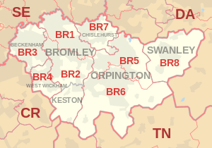
Map
Template:Attached_KML/BR postcode area
BR postcode area map, showing postcode districts in red and post towns in grey text, with links to nearby
CR,
DA,
SE and
TN postcode areas.
See also
References