Bückeberg (Hagenohsen)
From Wikipedia, the free encyclopedia
This article is about the Bückeberg hill in Hameln-Pyrmont, Germany. For the Bückeberg hills in Schaumburg, Germany, see Bückeberg.

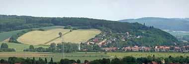
The Bückeberg with the mown fields of the former site of the Third Reich Harvest Festivals (Reichserntedankfeste)
The Bückeberg (160 m) is a hill that lies south of Hamelin on the eastern perimeter of the Weser village of Hagenohsen which is on the right-hand, eastern bank of the River Weser in central Germany.
The crest and the other slopes of the Bückeberg are covered with mixed forest. From the Weser village of Latferde further south a local road runs over the Bückeberg to Hagenohsen. From 1933 to 1937 the Reich harvest festival held by the Nazis took place on a large, artificially-levelled field on the western side of the Bückeberg. The municipality of Emmerthal has put forward a land use plan for the terrain of the Reich harvest festival.[1]
References
External links
![]() Media related to Bückeberg (Hagenohsen) at Wikimedia Commons
Media related to Bückeberg (Hagenohsen) at Wikimedia Commons
52°3′3″N 9°24′44″E / 52.05083°N 9.41222°E
This article is issued from Wikipedia. The text is available under the Creative Commons Attribution/Share Alike; additional terms may apply for the media files.