Armenian Highlands
| Armenian Highlands | |
 The Armenian Mountain Range near the Turkey-Iran border | |
| Country | Armenia Azerbaijan Georgia Iran Turkey |
|---|---|
| Highest point | Mount Ararat |
| - elevation | 5,137 m (16,854 ft) |
| - coordinates | 39°43′N 44°16′E / 39.717°N 44.267°E |
| Area | 400,000 km2 (154,441 sq mi) |
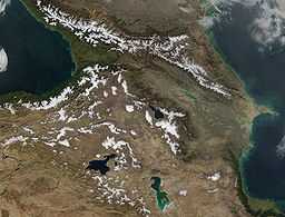 Satellite image
| |


The Armenian Highlands (for names in other languages see below; also known as the Armenian Upland, Armenian plateau, Armenian tableland,[1][2]) is the central-most and highest of three land-locked plateaus that together form the northern sector of the Middle East.[2] To its west is the Anatolian plateau which rises slowly from the lowland coast of the Aegean Sea and rises to an average height of 3,000 feet (910 m).[2] In Armenia, the average height rises dramatically from 3,000 feet (910 m) to 7,000 feet (2,100 m).[2] To its southeast is the Iranian plateau, where the elevation drops rapidly to an average 2,000 feet (610 m) to 5,000 feet (1,500 m) above sea level.[2]
During Antiquity, it was known as Armenia Major, a central region to the history of Armenians, and one of the three geo-political regions associated with Armenians, the other two being Armenia Minor and Sophene.[3][4] During the Middle Ages, Turkmens settled in large numbers in the Armenian Highlands. Due to this, the region was also sometimes referred to as Turcomania.
The region was historically inhabited by Hurro-Urartians, Armenians, Georgians, Assyrians, Kurds, Persians, Greeks, Arabs, Turks and Mongols. The Christian population of the Western half of the region was exterminated in an event known as the Armenian Genocide.
Today, the region is mainly inhabited by Armenians, Azerbaijanis, Georgians, Kurds and Turks.
Name
- Armenian: Հայկական լեռնաշխարհ Haykakan leṙnašxarh
- Turkish: Ermenistan Yaylası[5] or Ermenistan Platosu[6]
Political aspect
When the Treaty of Lausanne was signed in 1923, the Republic of Turkey was established. It is claimed that in its attempts to Turkify the geographical and settlement names in Turkey, the authorities of the republic began a systematic campaign to alter non-Turkish placenames. These attempts included the name change of the geographical expression of "Armenia" or "Armenian plateau" to "Eastern Anatolia."[7] However, as can be seen in Turkish sources, the names Armenian plateau (Ermenistan Platosu) or Armenian Highland (Ermenistan Yaylası) are used to define the plateau.[8][9][10] The term "Eastern Anatolia Region" is designated for the region and is mainly used for statistical purposes, while geographic expression Armenian plateau is continued to be used in contemporary Turkish sources.[citation needed]
Geography
Its total area is about 400,000 km².[11] Historically, the Armenian Highlands has been the scene of great volcanic activity.[12] Geologically recent volcanism on the area has resulted in large volcanic formations and a series of massifs and tectonic movement has formed the three largest lakes in the Highland, Lake Sevan, Lake Van and Lake Urmia.[13] The Armenian Highlands is rich in water resources.[14]

Most of the Armenian Highlands is in Turkey's Eastern Anatolia Region, and also includes northwestern Iran, all of Armenia, and western Azerbaijan.[11] Its eastern parts are also known as Lesser Caucasus, which is a birthplace of Armenian people.[15]
History
From 4,000 B.C. to 1,000 B.C., tools and trinkets of copper, bronze and iron were commonly produced in this region and traded in neighboring lands where those metals were less abundant.[citation needed] It is also traditionally believed to be one of the possible locations of the Garden of Eden.[16] The Armenian Plateau has been called the "epicenter of the Iron Age", since it appears to be the location of the first appearance of Iron Age metallurgy in the late 2nd millennium BC.[17] In the Early Iron Age, the kingdom of Ararat controlled much of the region.
In Gilgamesh, the land of Aratta is placed in a geographic space that could be describing the Armenian plateau.[18]
Throughout Classical Antiquity and the Middle Ages, the Armenian Highlands was a heavily contested territory of the Byzantine, the Ottoman, the Persian, and Arab spheres of influence. It was finally conquered by the Ottoman Empire in the 16th century, and during the 19th century, it was the boundary of the Ottoman and the Russian spheres of influence. According to Richard Hovannisian, the Armenian Genocide was the "physical elimination of the Armenian people and most of the evidence of their ever having lived on the great highland called the Armenian Plateau, to which the perpetrator side soon assigned the new name of Eastern Anatolia".[19] Since the Armenian Genocide and dissolution of the Ottoman Empire after World War I, it has been the boundary region of Turkey, Iran and the Soviet Union and, since the 1991 dissolution of the Soviet Union, Armenia, and parts of Georgia and Azerbaijan.[18]
Flora and fauna
The apricot was known by the Romans as the prunus armenicus (the Armenian plum) and was brought to Europe from the Armenian plateau.[2]
Notable peaks

| Rank | Mountain | Prominence | Location |
|---|---|---|---|
| 1 | Mount Ararat | 5,137 m | |
| 2 | Mount Aragats | 4,095 m | |
| 3 | Mount Süphan | 4,058 m | |
| 4 | Mount Kapudzhukh | 3,906 m | |
| 5 | Mount Azhdahak | 3,597 m | |
| 6 | Mount Kezelboghaz | 3,594 m | |
| 7 | Mount Artos | 3,515 m | |
See also
Notes
- ↑ Google Books search - Armenian tableland
- ↑ 2.0 2.1 2.2 2.3 2.4 2.5 Hewsen, Robert H. "The Geography of Armenia" in The Armenian People From Ancient to Modern Times Volume I: The Dynastic Periods: From Antiquity to the Fourteenth Century. Richard G. Hovannisian (ed.) New York: St. Martin's Press, 1997, pp. 1-17
- ↑ Adalian, Rouben Paul (2010). Historical dictionary of Armenia (2nd ed. ed.). Lanham, MD: Scarecrow Press. pp. 336–8. ISBN 0810874504.
- ↑ Grierson, Otto Mørkholm ; edited by Philip; Westermark, Ulla (1991). Early Hellenistic coinage : from the accession of Alexander to the Peace of Apamea (336-188 B.C.) (Repr. ed.). Cambridge: Cambridge University Press. p. 175. ISBN 0521395046.
- ↑ Elburz dağlarının güneyden gelen dağlarla birleştiği yere Ermenistan yaylası denir, Hürriyet Ansiklopedik Yıllığı, Hürriyet, Istanbul, 1974, p. 323.
- ↑ Güneye doğru Küçük Kafkas dağları ve yüksek Ermenistan Platosu başlar. Bu plato topografik açıdan Doğu Anadolu yüksek yaylası ve İran Azerbaycanı ile birlikte bir bütün meydana getirir., Aynur Özfırat, Doğu Anadolu Yayla Kültürleri: M.Ö. II. binyıl, Arkeoloji ve Sanat Yayınları, 2001, p. 13.
- ↑ Hovannisian, Richard G. "Etiology and Sequelae of the Armenian Genocide" in Genocide: Conceptual and Historical Dimensions. George J. Andreopoulos (ed.) Philadelphia: University of Pennsylvania Press, 1994, p. 127.
- ↑ Ermenistan'da iktidar mücadelesi: bağımsızlıktan günümüze çok. - Page 149, Hatem Cabbarlı - 2005
- ↑ Ermeni iddialarına yanıt: Gürcü Devleti'nin Kırmızı Kitap'ı - Page 36, Franz Furrer, Arif Acaloğlu - 2007
- ↑ Hoşgörü toplumunda Ermeniler. - Volume 4 - Page 430 M. Metin Hülagü - 2007 "Yunan tarihçisi Heredot yazıyor ki, Ermeniler Ermeni yaylası denilen yerin yalnız Batı hissesinde meskûnlaşmışlar".
- ↑ 11.0 11.1 "Armenian Highland." Encyclopædia Britannica. 2007. Encyclopædia
- ↑ Volcanoes, their structure and significance Thomas George Bonney - 1912 - Page 243
- ↑ Emerald Network Pilot Project in Armenia, Council of Europe.
- ↑ Der Völkermord an den Armeniern, Nikolaĭ Oganesovich Oganesian - 2005- Page 6
- ↑ Barbara A. West (2009). Encyclopedia of the Peoples of Asia and Oceania. Infobase Publishing. p. 47. ISBN 978-0-8160-7109-8. Retrieved 20 September 2011.
- ↑ Mesopotamian Trade. Noah's Flood: The Garden of Eden, W. Willcocks, H. Rassam pp. 459-460
- ↑ Lang, David M. Armenia: Cradle of Civilization. London: George Allen & Unwin, 1970, pp. 50-51, 58-59.
- ↑ 18.0 18.1 Encyclopedia of the Peoples of Asia and Oceania, By Barbara A. West, 2009, p. 47
- ↑ The Armenian Genocide: Cultural and Ethical Legacies - Page 3, by Richard G. Hovannisian - 2011
Further reading
- Hewsen, Robert H. (2001), Armenia: A Historical Atlas (1st ed.), Chicago, IL: University of Chicago Press, ISBN 0-226-33228-4
Coordinates: 39°17′1″N 43°22′19″E / 39.28361°N 43.37194°E