Ampney Crucis
From Wikipedia, the free encyclopedia
For the 2000 AD character, see Ampney Crucis Investigates.
Coordinates: 51°42′58″N 1°54′25″W / 51.716°N 1.907°W| Ampney Crucis | |
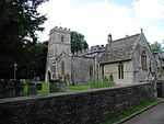 Church of the Holy Rood |
|
 Ampney Crucis | |
| Population | 609 |
|---|---|
| OS grid reference | SP0601 |
| District | Cotswold |
| Shire county | Gloucestershire |
| Region | South West |
| Country | England |
| Sovereign state | United Kingdom |
| Post town | Cirencester |
| Dialling code | 01285 |
| Police | Gloucestershire |
| Fire | Gloucestershire |
| Ambulance | Great Western |
| EU Parliament | South West England |
| |
Ampney Crucis (grid reference SP065019) is a village and civil parish in the Cotswolds, part of the Cotswold District of Gloucestershire, England. The parish has a population of 609. In the Domesday Book of 1086 it was held by Turstin FitzRolf.
The Ampney Brook flows through the village, which is near to Ampney St Mary and Ampney St Peter, and is about three miles east of Cirencester. The village takes its name from the brook and the local church, which is dedicated to the Holy Cross.
External links
-
 Media related to Ampney Crucis at Wikimedia Commons
 - Ampney Crucis
- Ampney [Crucis] in the Domesday Book
This article is issued from Wikipedia. The text is available under the Creative Commons Attribution/Share Alike; additional terms may apply for the media files.