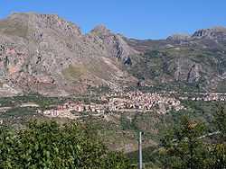
Alcara li Fusi
| Alcara li Fusi | |
|---|---|
| Comune | |
| Comune di Alcara li Fusi | |
 | |
 Alcara li Fusi | |
| Coordinates: 38°1′N 14°42′E / 38.017°N 14.700°ECoordinates: 38°1′N 14°42′E / 38.017°N 14.700°E | |
| Country | Italy |
| Region | Sicily |
| Province | Province of Messina (ME) |
| Area | |
| • Total | 62.3 km2 (24.1 sq mi) |
| Elevation | 400 m (1,300 ft) |
| Population (Dec. 2004) | |
| • Total | 2,339 |
| • Density | 38/km2 (97/sq mi) |
| Demonym | Alcaresi |
| Time zone | CET (UTC+1) |
| • Summer (DST) | CEST (UTC+2) |
| Postal code | 98070 |
| Dialing code | 0941 |
| Website | Official website |
Alcara li Fusi is a comune (municipality) in the Province of Messina in the Italian region Sicily, located about 120 km east of Palermo and about 80 km west of Messina. As of 31 December 2004, it had a population of 2,339 and an area of 62.3 km².[1]
Alcara li Fusi borders the following municipalities: Cesarò, Longi, Militello Rosmarino, San Fratello, San Marco d'Alunzio.
Geography
 Torretta del vecchio Castello Turiano |
The village is 398 meters above sea level on the slopes of the Nebrodi Mountains, which extend from the peaks of Mount Crasto (about 1,300 meters above sea level), to the northeast, to the plateau of Miraglia, with Mount Soro (1,847 meters above sea level).
The territory is rich in watercourses; in particular is the course of the river Rosmarino, a river which has shaped a profound valley which divides into two distinct and different parts the village territory. The central habitation is found on the bank to the right of the river below magnificent rocky outcrops of calcareous origin. The left side of the Rosmarino is instead constituted by reliefs rich in vegetation which arrive at the ridge of the Nebrodi Mountains and to the summit of Mount Soro (1847 meters above sea level).
History
One alleged legend, reported by historical scholars in past centuries but without any references om the popular tradition, narrates about the foundation of the village by Patrone, a Greek from the city of Turio in Magna Graecia following Aeneas, who had reached the coast after having landed with some companions. In reality there is no historical evidence which can link Alcara with Turio or rather identify Alcara with the Greco-Roman city of Turiano documented on fountains in the village, besides the denomination of the "Castle Turio," the remains of a fortification which dominates the village. Equally without any historical evidence is the identification of Alcara with the greco-Byzantine city of Demenna which in any case could reasonably be localized in the area of the Nebrodi, including the area between San Marco d'Alunzio, Alcara, and Longi. Controversial also is the locality of the greco-sicanian city of Crasto (Krastos) which according to various local historians fluctuates from Western Sicily, Southern Sicily, and Eastern Sicily, but that should not deviate too much from the area between Agrigento and Imera, despite the presence of rocky outcrops of "Crasto" just above the habitation of Alcara.
Demographic evolution
| Historical population | ||
|---|---|---|
| Year | Pop. | ±% |
| 1861 | 2,231 | — |
| 1871 | 2,473 | +10.8% |
| 1881 | 2,708 | +9.5% |
| 1901 | 3,095 | +14.3% |
| 1911 | 3,238 | +4.6% |
| 1921 | 3,278 | +1.2% |
| 1931 | 3,402 | +3.8% |
| 1936 | 3,500 | +2.9% |
| 1951 | 3,824 | +9.3% |
| 1961 | 3,618 | −5.4% |
| 1971 | 3,361 | −7.1% |
| 1981 | 3,038 | −9.6% |
| 1991 | 3,079 | +1.3% |
| 2001 | 2,473 | −19.7% |
| Source: Data from ISTAT | ||
References
External links
- www.comune.alcaralifusi.me.it/
- il sito del Santo patrono San Nicolò Politi
- Alcara li Fusi Online
- Le foto e tradizioni su Alcara
- www.nebrodifoto.com