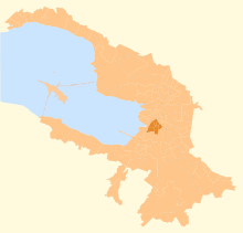
Admiralteysky District
From Wikipedia, the free encyclopedia
Coordinates: 59°55′9″N 30°17′48″E / 59.91917°N 30.29667°E

Admiralteysky District on the older map of St. Petersburg
Admiralteysky District (Russian: Адмиралте́йский райо́н) is a district of the federal city of St. Petersburg, Russia. It borders the Neva River in the north and in the west, the Yekateringofka River in the southwest, areas around Gorokhovaya Street in the east, and areas around Zagorodny Avenue in the south. District's population: 157,897 (2010 Census);[1] 187,837 (2002 Census).[2]
Admiralteysky District comprises the following municipal okrugs:
References
| Wikimedia Commons has media related to Admiralteysky District of Saint Petersburg. |
- ↑ "Всероссийская перепись населения 2010 года. Том 1" [2010 All-Russian Population Census, vol. 1]. Всероссийская перепись населения 2010 года (2010 All-Russia Population Census) (in Russian). Federal State Statistics Service. 2011. Retrieved June 29, 2012.
- ↑ "Численность населения России, субъектов Российской Федерации в составе федеральных округов, районов, городских поселений, сельских населённых пунктов – районных центров и сельских населённых пунктов с населением 3 тысячи и более человек" [Population of Russia, its federal districts, federal subjects, districts, urban localities, rural localities—administrative centers, and rural localities with population of over 3,000]. Всероссийская перепись населения 2002 года (All-Russia Population Census of 2002) (in Russian). Federal State Statistics Service. May 21, 2004. Retrieved February 9, 2012.
This article is issued from Wikipedia. The text is available under the Creative Commons Attribution/Share Alike; additional terms may apply for the media files.