Škocjan, Grosuplje
| Škocjan Staro Apno (until 1990), Škocjan pri Turjaku | |
|---|---|
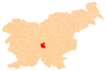
_location_map.svg.png) Škocjan | |
| Coordinates: 45°53′5.53″N 14°37′57.6″E / 45.8848694°N 14.632667°ECoordinates: 45°53′5.53″N 14°37′57.6″E / 45.8848694°N 14.632667°E | |
| Country |
|
| Traditional region | Lower Carniola |
| Statistical region | Central Slovenia |
| Municipality | Grosuplje |
| Area | |
| • Total | 2 km2 (0.8 sq mi) |
| Elevation | 492 m (1,614 ft) |
| Population (2002) | |
| • Total | 66 |
| [1] | |
Škocjan is a settlement in the Municipality of Grosuplje in central Slovenia. It lies in the hills south of Grosuplje, near Turjak. The area is part of the historical region of Lower Carniola. The municipality is now included in the Central Slovenia statistical region.[2]
Name
The name of the settlement was changed from Staro Apno to Škocjan (literally, 'Saint Cantius') in 1992.[3] Although many former religious names of settlements in Slovenian were restored after the fall of communism, this is one of the few cases of a settlement receiving a religious name after 1990 even though it did not have a religious name before the Second World War.[4]
Church
The parish church in the village is dedicated to Saint Cantius and belongs to the Roman Catholic Archdiocese of Ljubljana. It was first mentioned in written doucments dating to 1260 and restyled in the Baroque in the mid-18th century and extensively rebuilt in 1907. Part of the original church is preserved as a side chapel. The Slovene Protestant reformer Primož Trubar was christened in the chapel in 1508.[5]
References
- ↑ Statistical Office of the Republic of Slovenia
- ↑ Grosuplje municipal site
- ↑ Spremembe naselij 1948–95. 1996. Database. Ljubljana: Geografski inštitut ZRC SAZU, DZS.
- ↑ Urbanc, Mimi, & Matej Gabrovec. 2005. Krajevna imena: poligon za dokazovanje moči in odraz lokalne identitete. Geografski vestnik 77(2): 25–43.
- ↑ "EŠD 2514". Registry of Immovable Cultural Heritage (in Slovene). Ministry of Culture of the Republic of Slovenia. Retrieved 28 June 2011.
