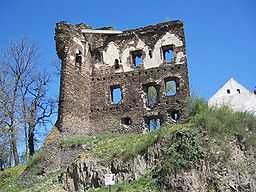
Říčany
- See other locations named Říčany.
| Říčany | |||
| Town | |||
 Říčany Castle | |||
|
|||
| Country | Czech Republic | ||
|---|---|---|---|
| Region | Central Bohemian | ||
| District | Prague-East | ||
| Commune | Říčany | ||
| River | Říčanský potok | ||
| Elevation | 341 m (1,119 ft) | ||
| Area | 25.80 km2 (9.96 sq mi) | ||
| Population | 12,429 (2006-07-03) | ||
| Density | 482 / km2 (1,248 / sq mi) | ||
| First mentioned | 1289 | ||
| Mayor | Vladimír Kořen (Klidné město) | ||
| Timezone | CET (UTC+1) | ||
| - summer (DST) | CEST (UTC+2) | ||
| Postal code | 251 01 | ||
  Location in the Czech Republic
| |||
 Location in Prague-East District
| |||
| Wikimedia Commons: Říčany | |||
| Statistics: statnisprava.cz | |||
| Website: www.ricany.cz | |||
Říčany (Czech pronunciation: [ˈr̝iːtʃanɪ]; German: Ritschan) is a town in the Central Bohemian Region of the Czech Republic. In 2006 it had almost 17,500 inhabitants. It is located 20 km from the center of Prague and it takes about half an hour to get to the Prague Main railway station by train. The town is part of the Prague metropolitan area.
The villages Jažlovice, Krabošice, Kuří, Pacov, Radošovice, Strašín and Voděrádky are administrative parts of Říčany.
Affiliations
Říčany is twinned with the following towns:
Schools
There are two primary schools in Říčany. The "First primary school" is located in the centre of the town, on Masaryk square. The "Second primary school" is located in the upper part of Říčany, Radošovice, on Bezruč street. There are also two secondary schools in Říčany: the state school Gymnázium Říčany and the private Masarykovo klasické gymnázium.
History
The first documents about the town date back to the year 1289. In the Middle Ages there was a large castle in Říčany, but during the Hussite Wars it was occupied and burnt out, and during the Thirty Years' War it was destroyed.
Sights
- Říčany Castle
- church of St. Peter and Paul on Masaryk square
- Marian column on Masaryk square
- Jureček lido in Radošovice (residential part of Říčany)
Events
- Starák - multicultural microfest (beginning of August)
- Říčanský nos - town festival (beginning of September)
External links
- Municipal website (in Czech)
Coordinates: 49°59′31″N 14°39′20″E / 49.99194°N 14.65556°E
| Wikimedia Commons has media related to Říčany. |

