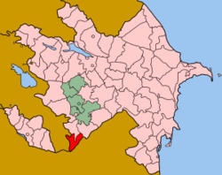
İçəri Muşlan
From Wikipedia, the free encyclopedia
Coordinates: 39°04′24″N 46°42′01″E / 39.07333°N 46.70028°E
| İçəri Muşlan | |
|---|---|
 İçəri Muşlan | |
| Coordinates: 39°04′24″N 46°42′01″E / 39.07333°N 46.70028°E | |
| Country |
|
| Rayon | Zangilan |
| Time zone | AZT (UTC+4) |
| • Summer (DST) | AZT (UTC+5) |
İçəri Muşlan (also, Ichari Mushlan) is a village in the Zangilan Rayon of Azerbaijan.
References
- '32FA881511433774E0440003BA962ED3'&Diacritics=DC İçəri Muşlan at GEOnet Names Server
- Azerbaijan Development Gateway
This article is issued from Wikipedia. The text is available under the Creative Commons Attribution/Share Alike; additional terms may apply for the media files.
