Česká Třebová
| Česká Třebová | |||
| Town | |||
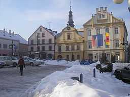
 Town hall in Česká Třebová | |||
|
|||
| Country | Czech Republic | ||
|---|---|---|---|
| Region | Pardubice | ||
| District | Ústí nad Orlicí | ||
| Commune | Česká Třebová | ||
| River | Třebovka | ||
| Elevation | 375 m (1,230 ft) | ||
| Coordinates | 49°54′6″N 16°26′52″E / 49.90167°N 16.44778°E | ||
| Area | 41.00 km2 (15.83 sq mi) | ||
| Population | 16,533 | ||
| Density | 403 / km2 (1,044 / sq mi) | ||
| First mentioned | 1278 | ||
| Mayor | Jaroslav Zedník | ||
| Timezone | CET (UTC+1) | ||
| - summer (DST) | CEST (UTC+2) | ||
| Postal code | 560 02 | ||
  Location in the Czech Republic
| |||
| Wikimedia Commons: Česká Třebová | |||
| Statistics: statnisprava.cz | |||
| Website: www.ceska-trebova.cz | |||


Česká Třebová (Czech pronunciation: [ˈtʃɛskaː ˈtr̝̊ɛbovaː]; German: Böhmisch Trübau) is a city in the Pardubice Region of the Czech Republic. The city is located in the east of the Czech Republic. It is the fourth most populated city and second largest in the Pardubice Region. Ceska Trebova is spread over 41 km² and in 2011 the total population was 16,000 citizens.
History
Česká Třebová was founded in the 13th century by king's locator lord Oldřich of Drnholec. In this time the Roman church of St. Catherine was built. In 1304, the King of Bohemia Wenceslaus II gifted it to the Zbraslav Abbey, but in 14th century the town belonged bishops of Litomyšl. In the 15th and 16th centuries the town prospered, but after the Thirty Years' War it was poor and insignificant. In 19th century was there a railway station, which greatly aided the city development.
Transports
The most important transport for Czech Trebova is rail, due to which the city developed rapidly after 1845, when there was a railway station.
Twin towns
 Agrate Brianza, Italy
 Oława, Poland
 Svit, Slovakia
External links
- Municipal website (Czech) (English)
- Information service (Czech) (English)
- Virtual show
| Wikimedia Commons has media related to Česká Třebová. |

