Ñuñoa
| Ñuñoa | ||||||
|---|---|---|---|---|---|---|
| City and Commune | ||||||
 | ||||||
| Coordinates (city): 33°27.5′S 70°36′W / 33.4583°S 70.600°WCoordinates: 33°27.5′S 70°36′W / 33.4583°S 70.600°W | ||||||
| Country | Chile | |||||
| Region | Santiago Metro. | |||||
| Province | Santiago | |||||
| Government[1] [2] | ||||||
| • Type | Municipality | |||||
| • Alcalde | Pedro Sabat Pietracaprina (RN) | |||||
| Area[3] | ||||||
| • Total | 16.9 km2 (6.5 sq mi) | |||||
| Population (2002 Census)[3] | ||||||
| • Total | 163,511 | |||||
| • Density | 9,700/km2 (25,000/sq mi) | |||||
| • Urban | 163,511 | |||||
| • Rural | 0 | |||||
| Sex[3] | ||||||
| • Men | 73,215 | |||||
| • Women | 90,296 | |||||
| Time zone | CLT [4] (UTC-4) | |||||
| • Summer (DST) | CLST [5] (UTC-3) | |||||
| Area code(s) | 56 + | |||||
| Website | Municipality of Ñuñoa | |||||


Ñuñoa (from Mapudungun Ñuñohue, "place of yellow flowers") is a commune of Chile located in Santiago Province, Santiago Metropolitan Region. Being the oldest commune of the traditional east part of Santiago, it has known to assimilate all the benefits of a big city (Metro, banks, Shopping mall, etc.) while still maintaining its character as a traditional and residential commune.[6]
Recently, the municipality's many attractions and convenient location have led to an increased desire by young urban professionals to live there. The commercial response has been to purchase properties on which to erect multiple-unit buildings, which has triggered criticism from long-time residents.[7] Ñuñoa has been chosen in 2007, for the third consecutive year, as the municipality with the highest living standard of Santiago.

Ñuñoa boasts bustling public and private sector businesses and a public transportation system capable of reaching all parts of the municipality. Most of Ñuñoa's commercial activity is localized along the Irarrázaval Avenue, a 6-km road that runs across the entire municipality from east to west, and centered in Plaza Ñuñoa, an area known for its bohemian night life. Ñuñoa is also home to Chile’s largest sports complex and to Santiago’s only mosque.
Demographics
According to the 2002 census of the National Statistics Institute, Ñuñoa spans an area of 16.9 km2 (7 sq mi) and has 163,511 inhabitants (73,215 men and 90,296 women), making the commune an entirely urban area. The population fell by 5.3% (9064 persons) between the 1992 and 2002 censuses.[3] The 2009 population was projected to be 149,205.[8]
Stats
- Autonomous household income per capita: US$34,409 (PPP, 2006)[9][10]
- Population below poverty line: 4.3% (2006)[9]
- Regional quality of life index: 87.66, high, 1 out of 52 (2005)[citation needed]
- Human Development Index: 0.860, 6 out of 341 (2003)[11]
Notable residents
- Soledad Alvear, senator
- Gutenberg Martinez, politician
- Jorge Arrate, politician
- José Balmes, painter
- Fanny Pollarolo, former deputy
- Mercedes Valdivieso, writer
- José Miguel Varas, journalist
- Alvaro Diaz Arambulo, philosopher
- Fernando Villegas, writer and political commentator
- Alex Deferrari, musician
- José Luis Rosasco, writer
- Poli Delano, writer
- Orlando Ezquerra, musician
- Gerardo Parra, magus Oli
Administration
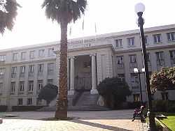
As a commune, Ñuñoa is a third-level administrative division of Chile administered by a municipal council, headed by an alcalde who is directly elected every four years. The 2008-2012 alcalde is Pedro Sabat Pietracaprina (RN).[1][2]
Within the electoral divisions of Chile, Ñuñoa is represented in the Chamber of Deputies by Jorge Burgos (PDC) and Marcela Sabat (RN) as part of the 21st electoral district, (together with Providencia). The commune is represented in the Senate by Soledad Alvear (PDC) and Pablo Longueira (UDI) as part of the 8th senatorial constituency (Santiago-East).
References
- ↑ 1.0 1.1 (Spanish) "Asociación Chilena de Municipalidades". Retrieved 27 January 2011.
- ↑ 2.0 2.1 (Spanish) "Municipality of Ñuñoa". Retrieved 27 January 2011.
- ↑ 3.0 3.1 3.2 3.3 (Spanish) "National Statistics Institute". Retrieved 13 December 2010.
- ↑ "Chile Time". WorldTimeZones.org. Retrieved 26 September 2010.
- ↑ "Chile Summer Time". WorldTimeZones.org. Retrieved 26 September 2010.
- ↑ Censo Comunal en ñuñoa (Spanish website)
- ↑ http://www.lanacion.cl/prontus_noticias_v2/site/artic/20070830/pags/20070830194512.html
- ↑ (Spanish) "System of Regional Information". Ministry of Planning of Chile. Retrieved 13 September 2010.
- ↑ 9.0 9.1 Casen poll, 2006, Ministry of Planning.
- ↑ Implied PPP conversion rate: World Economic Outlook Database, April 2010, International Monetary Fund.
- ↑ (Spanish) "The Trajectories of Human Development in the Communes of Chile (1994-2003)". Government of Chile, Mideplán. UNDP. Retrieved 12 September 2010.
External links
- (Spanish) Municipality of Ñuñoa
