Álamos
| Álamos | |
|---|---|
 | |
 Álamos | |
| Coordinates: 27°1′39″N 108°56′24″W / 27.02750°N 108.94000°W | |
| Country |
|
| State | Sonora |
| Municipality | Álamos |
| Founded | Late 17th century |
| Population (2005[1]) | |
| • Total | 24,493 |
| Time zone | MST (UTC-7) |
| Postal code | 85760 |
| Area code(s) | 647 |


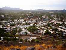
The town and municipality of Álamos in the Mexican state of Sonora was founded in the late 17th century following discoveries of silver in the region. It was named by the conquistador Francisco Vásquez de Coronado, and became the capital of the surrounding region. Alamos is the northern-most 'Silver City' in Mexico and although it has much in common, architecturally, with Mexico's other 'Silver Cities' it has not succumbed to large-scale commercialism and has managed to retain the charm and pace of earlier times. Many writers and artists have quietly claimed Alamos for their own.
Álamos is located in the southeastern part of Sonora, and 396 km (246 mi) from state capital Hermosillo, 54 km (34 mi) from Navojoa via Sonora State Highway 162, and 663 km (412 mi) from the northern border town of Nogales. It is adjoined by the State of Chihuahua on the east, and the State of Sinaloa on the south. The population of the municipality is 24,493 and its area 6,947.27 km². Average temperature is about 14 °C (58 °F); maximum 47 °C (117 °F).
Álamos is known as "La Ciudad de los Portales" (portales are tall, arched, covered verandas or walkways fronting many of the cobble-stoned streets or calles). Alamos boasts numerous buildings exhibiting classic architecture from Mexico's Colonial period, including the Plaza de Armas, the Church of La Purísima Concepción, La Capilla and the Palacio Municipal ("city hall"). The great wealth created by the silver mines from the surrounding mining towns of La Aduana, Minas Nuevas and San Bernardo enabled the founders and residents of Alamos to build scores of colonial Spanish mansions throughout the town; most of which were destroyed in the early 20th Century and restored by Americans and Canadians.
The economy of Alamos has long been depressed, contributing in large to the exodus of population and business. Nevertheless, in recent years much interest has developed in "birding." and many enthusiasts visit annually. True industry in the form of copper and silver mining have developed in the past three years in predominantly two areas, silver mining in the Cerro Colorado region to the south of Alamos and copper mining in the Piedras Verdes location to Northwest. The Sierra de Alamos Ecological Reserve, offers serious 'birding' opportunities. About 16 km to the West is the Adolfo Ruiz Cortinez Dam and Reservoir known as “El Mocúzarit”, whose waters irrigate 80,000 acres (320 km2). Cattle ranching is seasonal and declining due to impoverished grazing lands. Numerous chicken and pig farms, called "granjas," contribute substantially to the economy.
Many Festivals and fiestas occur in Álamos year-round, most notably the Festival of Dr. Alfonso Ortiz Tirado ("FAOT"), attended by many national and international musicians, and celebrities. Dr. Alfonso Ortiz Tirado, born in this community in 1894, achieved recognition for being "El Tenor de las Américas." An impressive exhibit of Ortiz Tirado is found in the Museo Costumbrista, located in front of and to the east of the Plaza de Armas. The annual Festival Alfonso Ortiz Tirado is a nine-day event that takes places in Alamos annually in late January.
The creek of Cuchujaqui, which is in the ecological reserve is the most subtropical area in the Northern Hemisphere. Cuchujaqui is the subject of international scientific study and the southern migration destination of hundreds of different species of birds.
Álamos was named a "Pueblo Mágico" in 2005. "Pueblo Magico" is a designation given by the Mexican Secretariat of Tourism to towns that offer a 'magical' experience by reason of their natural beauty, cultural riches and historical relevance.
Notable residents
- María Félix, film actress
- Gloria Fonda, film actress (died in Álamos)
- Arturo Márquez, composer
- Joaquin Murrieta, California bandit; however, Quillota, Chile, also claims him as a native son
- Álvaro Obregón, former President of Mexico
- Alfonso Ortiz Tirado, Physician, Tenor and Philanthropist
- Félix María Zuloaga, soldier, politician, former President of Mexico
Sister cities
Mars
The name Alamos has been used for a crater on the planet Mars by the International Astronomical Union, although not specifically commemorating the town.[2]
References
- ↑ (Spanish) 2005 census, INEGI.
- ↑ Categories for Naming Features on Planets and Satellites, Gazetteer of Planetary Nomenclature, USGS Astrogeology Science Center, NASA
External links
| Wikivoyage has a travel guide for Álamos. |
- Álamos, Ayuntamiento Digital (Official WebSite of Álamos, Sonora)
- Turismo Sonora
Coordinates: 27°01′39″N 108°56′24″W / 27.02750°N 108.94000°W