Água Grande District
| Água Grande | |
|---|---|
| District | |
 | |
| Coordinates: 0°20′N 6°44′E / 0.333°N 6.733°ECoordinates: 0°20′N 6°44′E / 0.333°N 6.733°E | |
| Country | São Tomé and Príncipe |
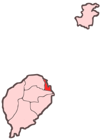
| Province/Island | São Tomé |
| Seat | São Tomé |
| Area | |
| • Total | 17 km2 (7 sq mi) |
| Population (2012 census) | |
| • Total | 73,091 |
| • Density | 4,300/km2 (11,000/sq mi) |
| Time zone | UTC (UTC+0) |
Água Grande is a district of São Tomé Province. Its capital, São Tomé, is also the provincial capital of São Tomé, and national capital of the equatorial Atlantic island nation of the Democratic Republic of São Tomé and Príncipe. Covering only 17 km2 (7 sq mi), it is the smallest of the nation's seven districts in terms of area, but the largest in population with an estimated 54,300 residents in 2004.
District Population History
- 1940 8,431 (13.9% of the national population)
- 1950 7,821 (13.0% of the national population)
- 1960 9,586 (14.9% of the national population)
- 1970 19,636 (26.6% of the national population)
- 1981 32,375 (33.5% of the national population)
- 1991 42,331 (36.0% of the national population)
- 2001 51,886 (37.7% of the national population)
Settlements
- Pantufo (pop: 1,929 in 2000, 2,169 in 2005)
- São Tomé
- 2001 community population: 49,957
Other
Água Grande has schools or collegiates (colegio), lyceums (middle schools), gymnasia (high schools), São Tomé and Príncipe's only hospital and airport, a stadium, churches, beaches, a port and a few squares (praças). The municipality is the most developed in São Tomé and Príncipe.
| Northwest: Lobata | North: Atlantic Ocean | |
| West: Lobata | Água Grande | East: Atlantic Ocean |
| South: Mé-Zóchi |
International relations
Twin towns – Sister cities
Água Grande District is twinned with:
References
- ↑ "Lisboa - Geminações de Cidades e Vilas" [Lisbon - Twinning of Cities and Towns]. Associação Nacional de Municípios Portugueses [National Association of Portuguese Municipalities] (in Portuguese). Retrieved 2013-08-23.
| ||||||||||