 |
This is a file from the Wikimedia Commons. Information from its description page there is shown below.
Commons is a freely licensed media file repository. You can help.
|
| DescriptionGreatWallofQinDynasty.png |
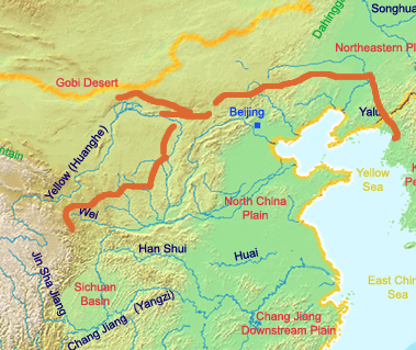
English: A map of the great wall of china of Qin Dynasty. The red lines indicate the Qin era wall. The yellow line indicates the current border of China.
Deutsch: Eine Karte der chinesischen Mauer zur Zeit der Qin Dynastie. Die rot eingezeichneten Teile der Mauer wurden zur Zeit der Qin Dynastie errichtet, gelb eingezeichnet sind die heutigen Grenzen Chinas.
|
| Date |
uploaded on 2007-07-08 |
| Source |
own work by Ksyrie
http://en.wikipedia.org/wiki/Image:GreatWallofQinDynasty.png (english Wikipedia) |
| Author |
Ksyrie |
Permission
( Reusing this file) |
Ksyrie at the English language Wikipedia, the copyright holder of this work, hereby publishes it under the following license:
 |
Permission is granted to copy, distribute and/or modify this document under the terms of the GNU Free Documentation License, Version 1.2 or any later version published by the Free Software Foundation; with no Invariant Sections, no Front-Cover Texts, and no Back-Cover Texts. A copy of the license is included in the section entitled GNU Free Documentation License. http://www.gnu.org/copyleft/fdl.htmlGFDLGNU Free Documentation Licensetruetrue
|
|
|
 Info Ksyrie made it from the blank map of en:Image:ChinaGeography.png and en:Image:Qin empire 210 BCE.png
File usage
The following pages on Schools Wikipedia link to this image (list may be incomplete):
Wikipedia for Schools is designed to make learning fun and easy. SOS Childrens Villages believes that a decent childhood is essential to a happy, healthy. Our community work brings families new opportunities through education, healthcare and all manner of support. If you'd like to help, learn how to sponsor a child.


