| Shigatse | |
|---|---|
| — County-level city — | |
| Xigazê | |
| Tibetan transcription(s) | |
| • Tibetan(abbreviated) | གཞིས་་རྩེ་ |
| • Wylie transliteration | gzhis ka rtse |
| Chinese transcription(s) | |
| • Traditional | 日喀則 |
| • Simplified | 日喀则 |
| • Pinyin | Rìkāzé |
| Downtown Shigatse, 1993 | |
|
Shigatse
|
|
| Coordinates: | |
| Country | People's Republic of China |
| Region | Tibet |
| Prefecture | Xigazê |
| Township-level divisions | 12 |
| Seat | Chengbei Subdistrict |
| Area[1] | |
| • Total | 3,654.18 km2 (1,410.9 sq mi) |
| Elevation | 3,836 m (12,585 ft) |
| Population (2008)[1] | |
| • Total | 92,000 |
| • Density | 25.2/km2 (65.2/sq mi) |
| Time zone | CST (UTC+8) |
| Postal code | 857000 |
| Area code(s) | 0892 |
Shigatse (simplified Chinese: 日喀则; traditional Chinese: 日喀則; pinyin: Rìkāzé; Tibetan: གཞིས་ཀ་རྩེ་, ZYPY: Xigazê; other spellings: Shikatse, Zhigatsey) is a county-level city and the second largest city in Tibet Autonomous Region (TAR), People's Republic of China, with a population of 92000, about 250 km (160 mi) southwest of Lhasa and 90 km (56 mi) northwest of Gyantse. It is the administrative centre of the modern Shigatse Prefecture, a region of the TAR.
The city is located at an altitude of 3,840 metres (12,600 ft) at the confluence of the Yarlung Tsangpo (aka Brahmaputra) river and the Nyang River (Nyang Chu or Nyanchue) in west Tibet and was the ancient capital of Ü-Tsang province. It is also the name of the surrounding county.
Contents |
Shigatse was previously known as Samdruptse.
In the 19th century the "Tashi" or Panchen Lama had temporal power over Tashilhunpo Monastery and three small districts, though not over the town of Shigatse itself, which was administered by two Dzongpön (Prefects) appointed from Lhasa.[2] Before military conflict between the PRC's People's Liberation Army and the Central Tibetan Administration, the Tibetan territory was divided into 53 prefecture districts called Dzongs.[3]
There were two Dzongpöns for every Dzong—a lama (Tse-dung) and a layman. They were entrusted with both civil and military powers and are equal in all respects, though subordinate to the generals and the Chinese Amban in military matters.[4] However, there were only one or two Ambans representing the Chinese emperor residing in Lhasa, directing a little garrison, and their power installed since 1728, progressively declined to end-up as observer at the eve of their expulsion in 1912 by the 13th Dalai Lama.[3] In 1952, shortly after the PRC sent forces to the region, Shigatse had a population of perhaps 12,000 people, making it the second largest city in Tibet.[5]
Shigatse lies on flat terrain surrounded by high mountains, and the urban area is located just south of the Yarlung Zangbo River, located in the south central part of the Tibet Autonomous Region. The city itself lies at an elevation of around 3,840 metres (12,600 ft), and within its administrative area there are 5 peaks taller than 5,500 metres (18,000 ft).[6] The city's administrative area ranges in latitude from 29° 07' to 29° 09' N and in longitude from 88° 03' to 89° 08' E.
Shigatse has a monsoon-influenced, alpine version of a humid continental climate (Köppen Dwb), with frosty, very dry winters and warm, wet summers. Temperatures are relatively moderate for the Tibetan Plateau, as the annual mean temperature is 6.3 °C (43.3 °F).[1] Barely any precipitation falls from November to March, when differences between day and night can frequently exceed 20 °C (36 °F). Nearly two-thirds of the annual rainfall occurs in July and August alone. Sunshine is abundant year-round, totalling 3248 hours annually.[6]
| Climate data for Shigatse (1971−2000) | |||||||||||||
|---|---|---|---|---|---|---|---|---|---|---|---|---|---|
| Month | Jan | Feb | Mar | Apr | May | Jun | Jul | Aug | Sep | Oct | Nov | Dec | Year |
| Average high °C (°F) | 6.2 (43.2) |
8.3 (46.9) |
11.9 (53.4) |
15.5 (59.9) |
19.5 (67.1) |
22.3 (72.1) |
21.3 (70.3) |
20.2 (68.4) |
19.1 (66.4) |
16.1 (61.0) |
11.0 (51.8) |
7.2 (45.0) |
14.9 (58.8) |
| Average low °C (°F) | −12.6 (9.3) |
−9.3 (15.3) |
−4.7 (23.5) |
−0.5 (31.1) |
3.5 (38.3) |
7.6 (45.7) |
8.8 (47.8) |
8.2 (46.8) |
5.8 (42.4) |
−1.2 (29.8) |
−8.3 (17.1) |
−12.1 (10.2) |
−1.2 (29.8) |
| Precipitation mm (inches) | .4 (0.016) |
.2 (0.008) |
.6 (0.024) |
2.1 (0.083) |
18.7 (0.736) |
64.0 (2.52) |
129.6 (5.102) |
152.3 (5.996) |
56.2 (2.213) |
5.4 (0.213) |
.9 (0.035) |
0 (0) |
430.4 (16.945) |
| Avg. precipitation days (≥ 0.1 mm) | .2 | .5 | .7 | 2.2 | 6.4 | 12.4 | 18.8 | 20.8 | 13.0 | 2.2 | .4 | .1 | 77.7 |
| Source: Weather China | |||||||||||||
Shigatse administers 2 subdistricts and 10 townships.[1]
| # | Name | Hanzi | Hanyu Pinyin | Tibetan | Wylie | Population (2008 est.) | Area (km²) |
|---|---|---|---|---|---|---|---|
| 1 | Chengbei Subdistrict | 城北街道 | Chéngběi Jiēdào | ? | ? | 6000 | 70 |
| 2 | Chengnan Subdistrict | 城南街道 | Chéngnán Jiēdào | ? | ? | 6000 | 90 |
| 3 | Lian Township | 联乡 | Lián Xiāng | ? | ? | 5000 | 514 |
| 4 | Nianmu Township | 年木乡 | Niánmù Xiāng | ? | ? | 3000 | 330 |
| 5 | Jiangdang Township | 江当乡 | Jiāngdāng Xiāng | ? | ? | 5000 | 304 |
| 6 | Bianxiong Township | 边雄乡 | Biānxióng Xiāng | ? | ? | 4000 | 230 |
| 7 | Dongga Township | 东嘎乡 | Dōnggā Xiāng | ? | ? | 9000 | 428 |
| 8 | Nierixiong Township | 聂日雄乡 | Nièrìxióng Xiāng | ? | ? | 5000 | 555 |
| 9 | Jiacuoxiong Township | 甲措雄乡 | Jiǎcuòxióng Xiāng | ? | ? | 12000 | 471 |
| 10 | Qubuxiong Township | 曲布雄乡 | Qǔbùxióng Xiāng | ? | ? | 5000 | 310 |
| 11 | Qumei Township | 曲美乡 | Qǔměi Xiāng | ? | ? | 6000 | 356 |
| 12 | Na'er Township | 纳尔乡 | Nà'ěr Xiāng | ? | ? | 2000 | 207 |
Shigatse contains the huge Tashilhunpo Monastery, founded in 1447 by Gendun Drup, the First Dalai Lama.[7] It is the traditional seat of the Panchen Lamas. Until the Chinese arrived in the 1950s, the "Tashi" or Panchen Lama had temporal power over three small districts, though not over the town of Shigatse itself, which was administered by a dzongpön (general) appointed from Lhasa.[2] In the 2nd week of the 5th lunar month (around June/July), Tashilhunpo Monastery is the scene of a 3-day festival and a huge thangka is displayed.[8]
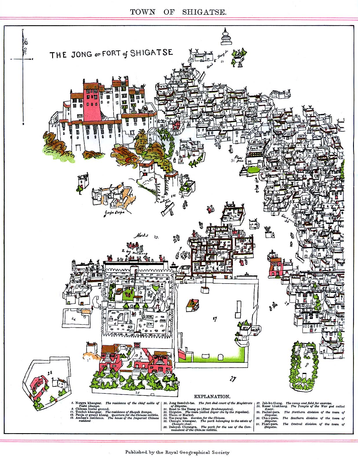
The imposing castle, Samdrubtse Dzong or "Shigatse Dzong", was probably built in the 15th century. It looked something like a smaller version of the Potala, and had turret-like fortifications at the ends and a central Red Palace. It used to be the seat of the kings of Ü-Tsang and the capital of the province of Ü-Tsang or Tsang.[9]
The castle was totally dismantled, rock by rock, by hundreds of Tibetans at the instigation of the Chinese in 1961.[10][11] Between 2005 and 2007, the building was reconstructed, financed by donations from Shanghai. The basis of the reconstruction were old photos, yet reconstruction was executed in cement/concrete.[12] Afterwards, the outside was to be wainscotted with natural stones. The dzong which, in the 17th century, clearly was taken as example when the Potala palace was constructed in Lhasa, is set to become a museum for Tibetan culture.
Nearby attractions include:
Media related to Shigatse at Wikimedia Commons
|
|||||||||||||