Montefortino
| Montefortino | |
|---|---|
| — Comune — | |
| Comune di Montefortino | |
|
Montefortino
|
|
| Coordinates: | |
| Country | Italy |
| Region | Marche |
| Province | Province of Fermo |
| Area | |
| • Total | 78.5 km2 (30.3 sq mi) |
| Elevation | 638 m (2,093 ft) |
| Population (Dec. 2005) | |
| • Total | 1,313 |
| • Density | 16.7/km2 (43.3/sq mi) |
| Demonym | Montefortinesi o fortinesi |
| Time zone | CET (UTC+1) |
| • Summer (DST) | CEST (UTC+2) |
| Postal code | 63047 |
| Dialing code | 0736 |
Montefortino is a comune (municipality) in the Province of Fermo in the Italian region Marche, located about 80 km south of Ancona, about 35 km northwest of Ascoli Piceno and about 45 km west of Fermo. As of 31 December 2005, it had a population of 1,313 and an area of 78.5 km².[1]
Montefortino borders the following municipalities: Amandola, Bolognola, Castelsantangelo sul Nera, Comunanza, Montemonaco, Sarnano, Ussita, Visso.
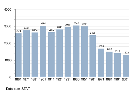
Demographic evolution
