| Hamarøy kommune | |||
|---|---|---|---|
| — Municipality — | |||
|
|||
| Hamarøy within Nordland | |||
| Coordinates: | |||
| Country | Norway | ||
| County | Nordland | ||
| District | Salten | ||
| Administrative centre | Oppeid | ||
| Government | |||
| • Mayor (2003) | Rolf Steffensen (AP) | ||
| Area | |||
| • Total | 1,031 km2 (398.1 sq mi) | ||
| • Land | 921 km2 (355.6 sq mi) | ||
| Area rank | 103 in Norway | ||
| Population (2006) | |||
| • Total | 1,821 | ||
| • Rank | 342 in Norway | ||
| • Density | 2/km2 (5.2/sq mi) | ||
| • Change (10 years) | -15.4 % | ||
| Demonym | Hamarøying Hamarøyværing[1] |
||
| Time zone | CET (UTC+1) | ||
| • Summer (DST) | CEST (UTC+2) | ||
| ISO 3166 code | NO-1849 | ||
| Official language form | Neutral | ||
| Website | www.hamaroy.kommune.no | ||
|
|
|||
Hamarøy (Lul. Sámi: Hábmer) is a municipality in Nordland county, Norway. It is part of the Salten traditional region. The administrative centre of the municipality is the village of Oppeid. Hamarøy was established as a municipality on 1 January 1838 (see formannskapsdistrikt).
Contents |
The municipality is named after the former island (now peninsula) Hamarøya (Old Norse: Hamarøy), since the first church was built there. The first element is the genitive case of Hǫm, the former uncompounded name of the island. The last element is øy which means "island". The former name of the island is probably identical with the word hǫm which means "thigh/leg (of an animal)" because the island (or a part of it) was shaped in the form of an animal's leg.
The coat-of-arms is from modern times. They were granted on 19 February 1982. The arms show a lynx (which are common in the area) as a symbol for the rich wildlife in the forests of the municipality.[2]
The municipality of Hamarøy borders the municipality of Tysfjord to the north, Steigen to the west, Sørfold to the south, Vestfjord to the northwest, and the country of Sweden to the southeast.
Lakes in the region include Fjerdvatnet and Forsanvatnet.
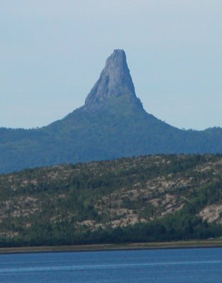
Hamarøy is dominated by small fjords, pine, birch, and aspen woodland and forest, and coastal mountains. There are several nature reserves, such as Trollpollen nature reserve dominated by pine and birch[3] located a few kilometers north of Innhavet, Lilandsvatnet wetland area,[4] Steinslandsosen estuary,[5] and Kvannskogen with old aspen trees with rich lichen flora.[6] The mountain Hamarøyskaftet has long been regarded as nature's own phallic symbol (See picture 1 and picture 2).
The warmest temperature ever recorded in Nordland county was 33.1°C on 3 July 1972 in Finnøya, Hamarøy. However, in June 2011 this record was surpassed by Saltdal with a recording of 33.8 C.
While Hamarøy has a low population density, it sees some traffic during the summer months as the main road connection to Svolvær and the Lofoten islands runs through Hamarøy and its administrative centre Oppeid. The ferry ride to Skrova and Svolvær is approximately 2 hours and departs Skutvik (approximately 15 minutes from Oppeid) at regular intervals. From 2008, the ferry schedule was considerably reduced due to the new Lofast road.
The municipal administration and other public services are located in Oppeid. There is a hotel in the municipality, as well as a scenic lighthouse which can be rented.[7]
Skutvik is a small residential and marina area concentrated around the ferry dock. In the high season the number of cars and motor homes in line for the ferry can be significant. There are a few sights to see in Skutvik, as well as a small bar/cafè and a Statoil gas station.
The writer Knut Hamsun, winner of the 1920 Nobel Prize in Literature, grew up in Hamarøy. The Knut Hamsun Centre, a museum and educational center dedicated to Knut Hamsun's life and work, finished building in 2009 and opened for the public in June 2010. Knut Hamsun's childhood home is also open for visitors in summer. The Hamsun literature festival was founded in 1982 and takes place in Hamarøy during the first week of August every second year.
|
|||||||