| Rif / Arif / ⴰⵔⵉⴼ | |
| Range | |
|
A view of the Rif mountains around Ashawen.
|
|
| Country | Morocco |
|---|---|
| Highest point | Tidighin |
| - elevation | 2,455 m (8,054 ft) |
|
Relief of the Atlas and the Rif.
|
|
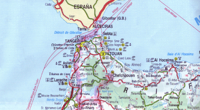
The Rif or Riff (Berber:ⴰⵔⵉⴼ Arif, Arabic:جبال الريف) is a mainly mountainous region of northern Morocco, with some fertile plains, stretching from Cape Spartel and Tangier in the west to Ras Kebdana and the Melwiyya River in the east, and from the Mediterranean Sea in the north to the river of Wergha in the south.
It is part of the Cordillera Bética that also includes the mountains of Southern Spain. The Rif mountains are not part of the Atlas Mountains but belong to the Gibraltar Arc or Alborán Sea geological region.
The region's name comes from the Berber word Arif. Major cities in the greter Rif region include Nador, Tangiers, Al Hoceima (also called Biya), Azghenghan, Selwan, Aâarwi, Imzouren, Ajdir, Targuist (Targist), Tittawin, Berkan, Taza, Tawrirt, and El Jebha.
Contents |
The Rif has been inhabited by Berbers since prehistoric times. As early as the 11th century BC, the Phoenicians began to establish trading posts, with approval of or partnership with the local Berbers, on the Mediterranean and Atlantic coasts, and founded cities such as Tetouan, Melilla (Rusadir) and, in the 5th century BC, Tangier (called Tingi, back then). Later the Carthaginians replaced the Phoenicians as the major power in the region. After the Third Punic War, Carthage was supplanted by Rome, and the Rif became part of the province of Mauretania. When the latter was divided during the rule of Emperor Claudius, Tangier became the capital of Mauretania Tingitana. In the 5th century AD, the region was raided by the Vandals, and Roman rule came to an end. The region remained under Vandal control until the 6th century AD when the Byzantines reconquered parts of it.
In 710, Salih I ibn Mansur founded the kingdom of Nekor in the Rif and Berbers started converting to Islam. Berber Muslim kingdoms started establishing more cities. By the 15th century, many Spanish Moors were exiled from Spain and most of them settled in the Rif, bringing their culture, Andalusian music, and even establishing the city of Ashawen (Accawen meaning "horns" in Berber). Since then, the Rif has suffered numerous battles between Berber kingdoms, Spain and Portugal. In 1415, Portugal invaded Ceuta (Sebta), and in 1490 Spain invaded Melilla (Mlilt). There was a period of peace afterwards, but war between Spain and Morocco broke out again in 1859 in Tetouan, where Morocco was defeated. The Spanish-Moroccan conflicts continued in the 20th century, under the leadership of Muhammad Ibn 'Abd al-Karim al-Khattabi, the Berber guerrilla leader. The Riffian Berbers struggled against Spanish rule and aimed to free the Rif from Spanish occupation. Abd el-Krim later established the Republic of the Rif in 1921. The region was returned to Morocco after the latter gained its independence in 1956.
The Rif mountains are not part of the Atlas mountain range. According to C. Michael Hogan, there are between five and eight separate subpopulations of the endangered primate Barbary Macaque, Macaca sylvanus.[1] The Rif mountains are also home to the honeybee Apis mellifera major.
The Rif region receives more rainfall than any other region in Morocco, with some portions receiving upwards of 2000mm of precipitation a year. The western and central portions are more rainy and are covered in forests of Atlas Cedar, Cork Oak and Holm Oak, as well as the only remaining forests of Moroccan Fir, a subspecies of the Spanish Fir. The eastern slopes receive less rainfall, and there forests consist mainly of pines, particularly the Aleppo Pine and the Maritime Pine, as well as Tetraclinis.
Massive deforestation due to overgrazing, forest fires, and forest clearing for agriculture, particularly for the creation of cannabis plantations, has taken place over the last century. This deforestation has led to soil degradation due to the washing away of topsoil, which has aggravated the process.
|
|||||