Cittaducale
| Cittaducale | |
|---|---|
| — Comune — | |
| Comune di Cittaducale | |
|
Cittaducale
|
|
| Coordinates: | |
| Country | Italy |
| Region | Latium |
| Province | Province of Rieti (RI) |
| Frazioni | Santa Rufina, Grotti, Calcariola, Pendenza, Cesoni, Micciani |
| Area | |
| • Total | 71.0 km2 (27.4 sq mi) |
| Elevation | 481 m (1,578 ft) |
| Population (Dec. 2004) | |
| • Total | 6,799 |
| • Density | 95.8/km2 (248/sq mi) |
| Demonym | Civitesi |
| Time zone | CET (UTC+1) |
| • Summer (DST) | CEST (UTC+2) |
| Postal code | 02015 |
| Dialing code | 0746 |
| Website | Official website |
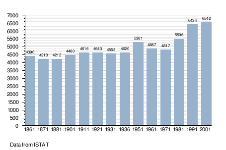
Cittaducale is a comune (municipality) in the Province of Rieti in the Italian region Latium, located about 70 km northeast of Rome and about 7 km southeast of Rieti. As of 31 December 2004, it had a population of 6,799 and an area of 71.0 km². It was once part of the Abruzzi Region.[1]
The municipality of Cittaducale contains the frazioni (subdivisions, mainly villages and hamlets) Santa Rufina, Grotti, Calcariola, Pendenza, Cesoni, and Micciani.
Cittaducale borders the following municipalities: Borgo Velino, Castel Sant'Angelo, Longone Sabino, Micigliano, Petrella Salto, Rieti.
Demographic evolution