Tegucigalpa
| Tegucigalpa | |||
|---|---|---|---|
 |
|||
|
|||
| Nickname(s): Tegus Tepaz Cerro de Plata (Silver Mountain) |
|||
 Tegucigalpa
|
|||
| Coordinates: | |||
| Country | |||
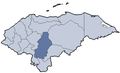
| Department | Francisco Morazán | ||
| Municipality | Distrito Central | ||
| Founded | 1578 | ||
| Capital | 1880 | ||
| Merged as Distrito Central | 1938 | ||
| Government | |||
| - Type | Democratic Municipality | ||
| - Mayor | Ricardo Álvarez (PNH) | ||
| Area | |||
| - City | 751.1 km2 (290 sq mi) | ||
| Elevation | 990 m (3,250 ft) | ||
| Population (2009) | |||
| - City | 1,200,000 | ||
| - Metro | 1,324,000 | ||


Tegucigalpa (Spanish pronunciation: [teɣusiˈɣalpa]) is the capital city of Honduras and is also the country's largest city. Tegucigalpa is also the capital of Honduras's Francisco Morazán department.
Contents |
History
Tegucigalpa was founded by Spanish settlers as Real Villa de San Miguel de Heredia de Tegucigalpa on September 29, 1578 on the site of an existing native settlement. Before and after independence, the city was a mining center for silver and gold. The capital of the independent Republic of Honduras switched back and forth between Tegucigalpa and Comayagua until it was permanently settled in Tegucigalpa in 1880.
A popular myth claims that the society of Comayagua, the long-time colonial capital of Honduras, publicly disliked the wife of President Marco Aurelio Soto, who took revenge by moving the capital to Tegucigalpa. A more likely theory is that the change took place because President Soto was an important partner of the Rosario Mining Company, an American silver mining company, whose operations were based in San Juancito, close to Tegucigalpa, and he needed to be close to his personal interests.
Tegucigalpa remained relatively small and provincial until the 1970s, when immigration from the rural areas began in earnest. During the 1980s, several avenues, traffic overpasses, and large buildings were erected, a relative novelty to a city characterized until then by two-story buildings. Tegucigalpa continues to sprawl far beyond its former colonial core, towards the east, south and west, creating a large but disorganized metropolis.
The city's main buildings include the former Presidential Palace, which is now a national museum, a 20th-century Legislative Palace, the headquarters of the Central American Bank for Economic Integration, the campus of the National University of Honduras founded in 1847, an 18th-century cathedral, and the Basilica of the Virgin of Suyapa.
Industrial production, small and mostly for local consumption, has increased since the 1970s with improved roadways. Products include textiles, clothing, sugar, cigarettes, lumber, plywood, paper, ceramics, cement, glass, metalwork, plastics, chemicals, tires, electrical appliances, and farm machinery. Some maquiladora duty-free assembly plants have been established since the 1990s in an industrial park in the Amarateca valley, on the northern highway. Silver, lead and zinc are still mined in the outskirts of the city.
Geography
Tegucigalpa is located on a chain of mountains at 14°5′N 87°13′W, at an elevation of 990 metres (3,250 ft). The Choluteca river, which crosses the city from south to north, physically separates Tegucigalpa and its sister city Comayagüa. El Picacho hill, a rugged mountain of moderate height convert rises above the downtown area; several neighborhoods, both residential and shantytowns, are located on its slopes. The city consists of gentle hills, and the ring of mountains surrounding the city tends to trap pollution. During the dry season, a dense cloud of smog lingers in the basin until the first rains fall.
Climate
Of the major Central American cities, Tegucigalpa's climate is among the most pleasant due to its high altitude. Like much of central Honduras, the city has a tropical climate, though tempered by the altitude—meaning less humid than the lower valleys and the coastal regions—with even temperatures averaging between 19 °C (66 °F) and 23 °C (73 °F) degrees. The months of December and January are coolest, whereas March and April—popularly associated with Holy Week’s holidays—are hottest. The dry season lasts from November through April and the rainy season from May through October.
| Climate data for Tegucigalpa | |||||||||||||
|---|---|---|---|---|---|---|---|---|---|---|---|---|---|
| Month | Jan | Feb | Mar | Apr | May | Jun | Jul | Aug | Sep | Oct | Nov | Dec | Year |
| Source: worldweather.org;[1] | |||||||||||||
Two capitals in one
For all practical purposes the capital of Honduras is Tegucigalpa, but some sources note that two “cities” share that designation. Chapter 1, Article 8, of the Honduran constitution states translated, "The cities of Tegucigalpa and Comayagüela, jointly, constitute the Capital of the Republic." Chapter 11, Article 295, translates, "The Central District consists of a single municipality made up of the former municipalities of Tegucigalpa and Comayagüela"; however, municipalities are defined in Honduras as political entities similar to counties, and they may contain one or more cities.
In a decree of October 30, 1880, President Marco Aurelio Soto established a permanent seat of government in Tegucigalpa, and in 1907 the episcopal now archiepiscopal see was translated there. On March 15, 1938, General Tiburcio Carías Andino and the National Congress declared that Comayagüela was a barrio neighbourhood of Tegucigalpa, the national capital. Today some government offices are listed with Comayagüela addresses, but the area is considered a part of Tegucigalpa.
Hurricane Mitch
On October 30, 1998, the city was significantly damaged by Hurricane Mitch. It destroyed part of the Comayagüela section of the city, as well as other places along the banks of the Choluteca river. The storm remained over Honduran territory for five days, dumping heavy rainfall late in the rainy season. The ground was already saturated and could not absorb the heavy precipitation, while deforestation and debris left by the hurricane led to catastrophic flooding throughout widespread regions of the country, especially in Tegucigalpa.
The heavy rain caused flash floods of Choluteca's tributaries, and the swollen river overflowed its banks, tearing down entire neighborhoods and bridges across the ravaged city. The rainfall also triggered massive landslides around El Berrinche hill, close to the downtown area. These landslides destroyed most of the Soto neighborhood, and debris flowed into the river, forming a dam. The dam clogged the waters of the river and many of the low-lying areas of Comayagüela were submerged; historic buildings located along Calle Real were either completely destroyed or so badly damaged that repair was futile.
Tegucigalpa today
Tegucigalpa is divided presently into "barrios" and "colonias". The latter represent relatively recent 20th-century middle class residential suburbs that are continuously spreading while the former are old inner-city neighborhoods. Most of the city's outskirts are "barrios marginales", shantytowns that house the poorest elements of Honduran society. The marked difference between social classes in Honduras is evident in Tegucigalpa with its largely improvised growth.
Population

According to 2005 estimates, the city of Tegucigalpa has approximately 1.25 million people. The city-dwellers are predominantly Spanish-speaking mestizos with a small white Hispanic minority. They are joined by Chinese and Arab immigrants, the latter mostly from Palestine. There are indigenous Amerindians and Afro-Honduran people as well. Further information may be found under Demographics of Honduras.
Politics
The local government—at its level, by far the most important in the country—is headed by Ricardo Álvarez, the current mayor of Tegucigalpa, from the National Party of Honduras. Tegucigalpa and Comayagüela form one single district, called Distrito Central (DC for short), which is difficult to manage due to its large size and population and myriad needs, amidst widespread corruption and poverty.
Places of interest
There are several conventional tourist attractions in Tegucigalpa. Some interesting places include:
- Parque La Leona
- the Metropolitan Cathedral
- Villa Roy Museum
- the former Presidential Palace (now a museum)
- the Museum of National Identity
- the National University
- the Basilica of the Virgin of Suyapa
- La Tigra National Park
- Picacho Hill and its zoo
- Chiminikee (a science park and museum for children).

There are several charming colonial villages within easy driving distance from Tegucigalpa: Santa Lucia (12 km/7 mi away), Valle de Angeles (21 km/13 mi away), Ojojona, Yuscarán and San Juancito. Each has its own distinct character and sense of history and all of them make easy day-trips out of the city.
Around the city
Tegucigalpa, as a colonial city, has several barrios in the oldest districts of the city and Comayaguela, and colonias in the new ones. None of them have well-defined limits or even town-centers. There are some boulevards, none of which reach into downtown. Like in most Central American cities, there doesn't seem to be much rhyme or reason as to how streets are named, making orientation and driving rather difficult to first-time visitors to the city.
Colonia Palmira, a wealthy neighborhood to the east of the city center on the Boulevard Morazan, hosts many of the foreign embassies as well as upscale restaurants. Lomas del Guijarro, Loma Linda and El Hatillo are upscale neighborhoods that house most of the apartment complexes in the city. The leading hotels of the city are found around these districts too. These include: Mariott Hotel, Clarion Hotel, Hotel El Centenario, Intercontinental, Honduras Maya, Plaza Del Libertador, Plaza San Martín, Hotel Alameda, Excelsior Hotel and Casino.
Museums
There are a handful of history and art museums in the city: Identidad Nacional (recently founded), Nacional Villaroy, del Hombre, Historico Militar, Historia Natural and Galeria de Arte Nacional. Besides, the Centro Cultural de España en Tegucigalpa - CCET or the Sala Bancatlan (Banco Atlántida) offer some arts exhibitions occasionally.
Shopping centers
The epicenter of shopping in Tegucigalpa is Multiplaza, a multi-level indoor shopping mall that includes a major grocery store, a movie theater complex, restaurants, banking and of course, many retail shops. Newer malls include Las Cascadas and MetroMall, both with stores and restaurants. MetroMall includes a sizeable movie theater complex.
Smaller shopping centers and strip malls can be found all over the city, including Los Castaños, El Dorado,Plaza Miraflores and the new Los Proceres center.
Bilingual schools
There are two modalities: American Period (September to July) Latin Period (February to November), all are included in the Educative District No. 5 of Bilingual School of Tegucigalpa and near. The languages of the Schools are English and Spanish as main languages, only the Lycée Franco-Hondurien has French, Spanish, and English as main languages.
Universities
Tegucigalpa is the national education center, with most universities and higher education institutions based there.
a) State-Funded: National Autonomous University of Honduras (Universidad Nacional Autónoma de Honduras)[2] (UNAH), founded in 1847, and Universidad Pedagógica Nacional Francisco Morazan,[3] founded in 1989 (UPNFM).
b) Privately Funded: Universidad Jose Cecilio del Valle,[4] founded in 1978; Universidad Tecnologica Centroamericana[5] (UNITEC), founded in 1986 in Jacaleapa, member of Laureate International Universities; Universidad Católica de Honduras,[6] founded by the Catholic Church in 1992; the Pan-American Agricultural School or Escuela Agricola Panamericana (widely known as Zamorano),[7] located in Zamorano valley, 30 km (19 mi) east of the city, founded in 1941; and Universidad Tecnológica de Honduras (UTH),[8] founded in 1986.
Transportation
Airport

Toncontin International Airport serves as the major airport in and out of Tegucigalpa. The origin of this name is unknown. This airport is frequently criticized as being dangerous (due to its location next to a sierra, its short runway, and difficult approach, which requires large commercial jets to execute a tight hairpin leftward u-turn at very low altitude to land on a very short runway—American Airlines pilots, for example, receive additional, specific training for the Toncontin approach). The hope is that additional air service carriers will choose to fly in and out of Toncontin. Efforts have been made for years to replace it with Palmerola airport in Comayagua, currently a Honduran and American Air Force base. Toncontín has been improved by the work of CAT (the Airport Corporation of Tegucigalpa) which is owned by TACA of El Salvador and by INTERAIRPORTS, a company hired by the government of Honduras to manage the four airports of the country. On May 30, 2008, there was a plane crash in the airport, in which TACA airline jet skidded off the runway, across a busy road and slammed into an embankment, crushing two cars. The crash killed five people and injured 65. President Manuel Zelaya announced that all commercial flights would be transferred to Palmerola, but there still has to be confirmation of this arrangement because Palmerola isn't ready to take in commercial flights immediately. Toncontin was reopened almost a month later, after extensive investigations on the accident proved that it had been the pilot's mistake and that neither the runway nor the airport had responsibility over the accident. The pilot landed almost halfway along the runway after being warned by the airport's control tower.
Airlines at Toncontin
- American Airlines, to Miami only, daily
- Grupo TACA, (flights to San Salvador, and San Pedro Sula mainly)
- Continental Airlines, to Houston only, daily
- Copa Airlines, to Panama and San Jose (CR), daily
- Delta Air Lines, to Atlanta only, Thursday to Monday
Sports
Tegucigalpa is home to Club Deportivo Olimpia and Club Deportivo Motagua, members of the Honduran National Soccer League. Between the two teams, they have won more than 30 championships. They play their home games at Estadio Nacional Tiburcio Carias Andino.
There are also inter-city school sports championships.
There is a Coliseum used mainly for basketball but is also used as a music concert venue. There is also what is called a "Villa Olimpica" to practice Olympic sports such as boxing, archery, tennis and tae-kwon-do; it is located close to the National University.
Future
Although the city has suffered from the 2008 worldwide recession, there are many construction projects on the way. The city has seen an emergence of vertical construction like never before.

Other sights
 Traditional dance in the main square |
 Replica of the Pre-Columbian Temple Pyramid in Concordia Park. |
Sister cities
 Taipei, Taiwan
 Madrid, Spain
 Lima, Peru
 Bogotá, Colombia
 Belo Horizonte, Brazil
 New Orleans, United States
 Guadalajara, Mexico
 Guatemala City, Guatemala
 Amman, Jordan
 La Paz, Bolivia
 Seoul, South Korea
References
- ↑ "(English) Weather Information for Tegucigalpa". http://www.worldweather.org/133/c00283.htm. Retrieved June, 5, 2010.
- ↑ UNAH.hn
- ↑ UPNFM.edu.hn
- ↑ UJCF.edu.hn
- ↑ Unitec.edu
- ↑ Unicah.edu
- ↑ Zamorano.edu
- ↑ UTH.hn
External links
|
|||||||||||